3.1.4.7 Glacial Systems and landscapes - Case studies
16 views 0 purchase
Course
3.1.4.7 Glacial Systems - Case Studies
Institution
AQA
Notes on:
- Case study(ies) of glaciated environment(s) at a local scale to illustrate and analyse fundamental glacial processes, their landscape outcomes as set out above and engage with field data.
- Case study of a contrasting glaciated landscape from beyond the UK to illustrate and analys...
3.1.4.7 Case studies
Case study(ies) of glaciated environment(s) at a local scale to illustrate and analyse
fundamental glacial processes, their landscape outcomes as set out above and engage
with field data.
Nant Ffrancon, North Wales
The Nant Ffrancon region of North Wales exhibits features
typical of a glacial eroded landscape, together with aspects
of a periglacial landscape. Geomorphologists believe that
the ice in this area could once have been made up to an
altitude of between 820m and 860m OD (Ordnance Datum),
though the last time that ice was that extensive in the area
may have been 40,000 BP, with slightly less ice 20,000 BP.
Nant Ffrancon itself is a glaciated valley, or trough, that was
produced by a northwesterly-moving glacier flowing away from the central part of
Snowdonia. Nant Ffrancon is a wide, flat-bottomed and straight valley, with typical glaciated
features of truncated spurs and vertical crags caused by the former interlocking spurs
having been clipped by the moving glacier. At the head of the valley there is a rock step,
marked by a waterfall – Rhaeadr Ogwen, which is 100m high due to the resistant hard
igneous (granitic) rock of the area. At the lower end of the valley is a terminal moraine. This
is where material was deposited by the moving glacier as it came to a standstill as the glacial
budget was in equilibrium (accumulation equalling ablation).
Development of the valleys and their landscape
The Nant Ffrancon and Ogwen valleys originally drained in opposite directions, with streams
going NW and E respectively. The watershed would have roughly been where Pen y Ole Wen
is today. The reasons for the erosion of the watershed are subject to debate. During the
Devensian, ice reached its furthest extent around 20,000 years ago with ice sheets across
most of Wales and the Midlands finishing in East Anglia. At this point North Wales would
have been affected by an ice cap. One theory is that a large glacier emerged from Migneint
Moor, to the south, flowing north, and as the Ogwen valley filled with ice it forced its way
over the watershed into the Nant Ffrancon valley, producing what is known as a diffluent col
and trough. An alternative theory is that the small glaciers emanating from the corries
immediately to the S and SW of the valleys (probably the Glyder cwms and area around
Tryfan) eroded the watershed. As no erratics from the Migneint Moor area have been
found, this would support the latter theory that ice travelled from the inland moor.
This was followed by a period of warming, and with rising temperatures the ice sheet
melted. The Ogwen area of North Snowdonia would have had valley glaciers fed by smaller
corrie glaciers. Gradually the snouts of these glaciers retreated back up the valley sides until
,only small corrie glaciers were left. We would have last had these conditions during the Loch
Lomond re-advance, approx. 12,000 BP. These too then would have disappeared as
temperatures continued to rise.
The valley exhibits common features of a glaciated landscape. At the head of the valleys are
several corries or cwms. However, many of these corries do not fit in with the typical
pattern of circular corries, often infilled with tarns. For example, Cwm Idwal is 1.5km in
length and only 1km wide from arete to arete. It is also both deeper and lower in altitude
than most other corries. Its floor is at an altitude of 375m, compared to the surrounding
corries, Cwm Bochlwyd (550m), Cwm Cneifion (600m) and Cwm Clyd (660m). It is thought
that this is because the col above it was low enough to allow ice to spill over from the
Llanberis Pass, meaning that Cwm Idwal had greater volumes of ice in it and therefore
would have been subjected to greater amounts of erosion. Furthermore, it lies along a line
of geological weakness – the bedrock here is part of a syncline and so overall erosion would
have been greater. However, the tarn, Llyn Idwal, has a linear shape and is surprisingly
shallow with a 10m depth at its maximum, but an average depth of 3m. Its mouth is
dammed by a small end moraine, and much of the land around it is hummocky. Hummocky
moraine is a common feature in many areas of the two valleys. Lateral moraine runs parallel
to Llyn Idwal along its western side. It has a classic triangular cross section and is around
300m in length. However there are other theories towards its formation. One is that it is a
protalus rampart, another that it is the recessional moraine for a glacier that reached across
Cwm Idwal from Cwm Cneifon.
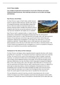
Above the tarn in Cwm Idwal there are steep, jagged and diagonally slanting rocks called the
Idwal Slabs. They are slanted because they are part of the syncline rock structure. Dilatation
(pressure release) has added to the weathering of the slabs. They are now heavily
weathered, creating screes at their base; they are also a challenge for rock climbers. Above
these rocks lie a series of knife-shaped edges or aretes.
Idwal Slabs
Y Gribin is an arete in another part of the area, separating Cwm Cneifion and Cwm
Bochlwyd. Both of these corries were eroded back into the Glyder mountains, and over
time, the glaciers in these cwms would have increased in size and begun to erode backwards
into the mountain plateau, leaving the sharp ridge between them.
Truncated spurs are also a widespread feature of both valleys – e.g. the end of Gribin Ridge
near Cwm Idwal, marking the residuals of previously interlocking spurs.
, There is a terminal moraine on the western side of Nant Ffrancon. This was formed by the
glacier from Cwm Coch. Similar features can be seen in the Alps today. This is where
material was deposited at the end of the glacier which flowed down from this corrie high up
above the U-shaped valley.
Glacial landforms in the Nant Ffrancon/ Ogwen area:
- Glacial trough – Nant Ffrancon
- Truncated spurs – several on the sides of Nant Ffrancon
- Arete – Y Gribin (separates Cwm Bochlwyd and Cwm Cneifion)
- Ribbon lake – Llyn Ogwen
- Cwm: Cwm Idwal
- Hanging valley: from Cwm Cywion (west of Nant Ffrancon)
- Rock step: Rhaeadr Ogwen (western end of Llyn Ogwen ribbon lake)
- Misfit stream: Afon Ogwen
Post-glacial modification
Post-glacially, meltwater filled the valley to produce a ribbon lake in the over-deepened
Nant Ffrancon valley. This ribbon lake had a natural dam to the NW caused by a rock barrier,
close to the present-day town of Bethesda. As the lake filled with sediments from the
streams flowing into the sides of the lake, it produced a flat floor. Today a misfit stream
meanders across the flat floor, in places exposing striated rocks as it erodes away the lake
sediments. Down the sides of the valley there are typical features of triangular shaped
alluvial fans deposited by streams flowing off the mountains on either side. These streams
slow down significantly and hence shed their load to create the fans. Another common
feature is the number of deep, steep-sided gorges cut back into the valley sides as
waterfalls, marking the location of the hanging valley retreat due to fluvial erosion.
Since the end of the ice ages, there have been other modifications caused by the periglacial
and subsequent processes affecting the area:
- Periglacial – extreme cold temperatures that continued to occur after the ice retreat
have created features similar to those of classic periglacial areas, e.g. stones stripes
and circles. It is clear that for a period of time there would have been permafrost in
the area.
- Weathering – the usual frost shattering processes that result from alternate freeze-
thaw cycles during the long winters that this area experiences have created
extensive areas of scree on the slopes below ridges and aretes. Higher up the slopes
and on the mountain summits, collections of larger rock fragments have created
blockfields. These have occurred due to the solifluction processes that took place in
periglacial times, allowing the transport of large rocks by the slow-moving saturated
soil during the warmer periods. It is thought that the large blockfields on the Glyder
and Carneddau summits would have been above the glacial ice and were therefore
shaped by extreme cold and periglacial processes but were not scoured by ice. The
clear break between the slightly lower ice-scoured and rounded ground (such as
above the Devil’s Kitchen) and these higher-up rocky blockfields provides evidence of
the depth of the ice described earlier.
The benefits of buying summaries with Stuvia:
Guaranteed quality through customer reviews
Stuvia customers have reviewed more than 700,000 summaries. This how you know that you are buying the best documents.
Quick and easy check-out
You can quickly pay through credit card or Stuvia-credit for the summaries. There is no membership needed.
Focus on what matters
Your fellow students write the study notes themselves, which is why the documents are always reliable and up-to-date. This ensures you quickly get to the core!
Frequently asked questions
What do I get when I buy this document?
You get a PDF, available immediately after your purchase. The purchased document is accessible anytime, anywhere and indefinitely through your profile.
Satisfaction guarantee: how does it work?
Our satisfaction guarantee ensures that you always find a study document that suits you well. You fill out a form, and our customer service team takes care of the rest.
Who am I buying these notes from?
Stuvia is a marketplace, so you are not buying this document from us, but from seller mollyidean. Stuvia facilitates payment to the seller.
Will I be stuck with a subscription?
No, you only buy these notes for $7.35. You're not tied to anything after your purchase.