GENERAL NAVIGATION
Summary / Notes
General navigation
, Table of contents
Section 1 – Basics of navigation
The earth ............................................................................... 2
Magnetism, Directions and Distances .........................................3
Latitude, Longitude and Distances .............................................. 5
Rhumb lines and great circles ..................................................... 5
Speed and Velocity… ................................................................ 6
Triangle of Velocity ................................................................... 6
Section 2 – Navigation Computer
Use of the wind side ................................................................... 7
Use of the calculator side ........................................................... 8
Solar System… ...................................................................... 8
Time… ................................................................................... 9
Section 3 – Maps and Charts
Charts… ............................................................................. 11
Mercator Projections .............................................................. 15
Conical Projections… .............................................................15
Azimuthal Projections… ......................................................... 16
Dead Reckoning Navigation ............................................. 17
Plotting… ........................................................................... 18
Visual Navigation – Map reading ........................................... 19
1
, Chapter 1 - The Earth
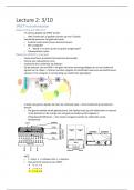
Shape of the Earth
-Perfect = Spherical
-Actual = Ellipsoid (Oval)
WGS-84 = World Geodetic System
-Reference Ellipsoid
-Horizontal / Vertical datum
-Coordinate system
The Geoid
-Imaginary = global mean sea level
-Wavy surface -> only influenced by gravity and centrifugal force
Dimensions Earth
-Circumference = 40000 km
-Equator -> pole = 10000 km
Rotation Earth
-NP = anti-clockwise
-SP = clockwise
-Direction of rotation = facing east
Great circles
-Shortest distance between 2 points
-Radio waves -> Travel great circles
-Cuts the centre of the earth
-All other circles = small circles
Parallels / Meridians
-Parallel = Small circles parallel to equator
-Meridian = Half of great circle (Anti meridian)
*zero meridian = Greenwich meridian
Rhumb lines (RL)
-Parallels of latitude
-Crosses meridians at a constant angle
Latitude (N or S)
-Height of the parallel
-Equator = 0°, Poles = 90°
-Geocentric = Angle between line point on surface to centre
-Geodetic (Geographic) = To line normal to meridian
2
Summary / Notes
General navigation
, Table of contents
Section 1 – Basics of navigation
The earth ............................................................................... 2
Magnetism, Directions and Distances .........................................3
Latitude, Longitude and Distances .............................................. 5
Rhumb lines and great circles ..................................................... 5
Speed and Velocity… ................................................................ 6
Triangle of Velocity ................................................................... 6
Section 2 – Navigation Computer
Use of the wind side ................................................................... 7
Use of the calculator side ........................................................... 8
Solar System… ...................................................................... 8
Time… ................................................................................... 9
Section 3 – Maps and Charts
Charts… ............................................................................. 11
Mercator Projections .............................................................. 15
Conical Projections… .............................................................15
Azimuthal Projections… ......................................................... 16
Dead Reckoning Navigation ............................................. 17
Plotting… ........................................................................... 18
Visual Navigation – Map reading ........................................... 19
1
, Chapter 1 - The Earth
Shape of the Earth
-Perfect = Spherical
-Actual = Ellipsoid (Oval)
WGS-84 = World Geodetic System
-Reference Ellipsoid
-Horizontal / Vertical datum
-Coordinate system
The Geoid
-Imaginary = global mean sea level
-Wavy surface -> only influenced by gravity and centrifugal force
Dimensions Earth
-Circumference = 40000 km
-Equator -> pole = 10000 km
Rotation Earth
-NP = anti-clockwise
-SP = clockwise
-Direction of rotation = facing east
Great circles
-Shortest distance between 2 points
-Radio waves -> Travel great circles
-Cuts the centre of the earth
-All other circles = small circles
Parallels / Meridians
-Parallel = Small circles parallel to equator
-Meridian = Half of great circle (Anti meridian)
*zero meridian = Greenwich meridian
Rhumb lines (RL)
-Parallels of latitude
-Crosses meridians at a constant angle
Latitude (N or S)
-Height of the parallel
-Equator = 0°, Poles = 90°
-Geocentric = Angle between line point on surface to centre
-Geodetic (Geographic) = To line normal to meridian
2