1 Introduction etc.
2 Generic Hydrologeological Systems
2.1 Lowland
2.1.1 Accumulation- and coastal areas
The amount of water that can be stored in a soil is depend on the amount of pores space.
The 𝒕𝒐𝒕𝒂𝒍 𝒑𝒐𝒓𝒐𝒔𝒊𝒕𝒚 = 𝒔𝒑𝒆𝒄𝒊𝒇𝒊𝒄 𝒚𝒊𝒆𝒍𝒅 + 𝒔𝒑𝒆𝒄𝒊𝒇𝒊𝒄 𝒓𝒆𝒕𝒆𝒏𝒕𝒊𝒐𝒏, this relative importance of these
terms is largely depend on the grain size distribution. Clay has a high total porosity with a high
specific retention but low specific yield, moreover cobbles have a lower total porosity but a much
higher specific yield and way lower specific retention.
Close to the coastlines and area’s close to the coast are called accumulation- and coastal
areas, this name comes from the fact that here sediments from the hinterland are deposited in a
sedimentary basin.
This sedimentary basin is mainly filled with marine sediments (2 million years ago),
nowadays it is deeper in the soil overlain by other sediments. The water present in these layers is still
salt.
The coastal deposits are known for their high porosity, however the conductivity is low, due to a
small grain size.
Later on the salt water area was overlain by deposits of Pleistocene (<10.000, east and south NL) and
Holocene(>10.000 west and north). During the Holocene fresh water is formed on top of sediments.
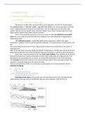
Dunes have a special property, it can have fresh water bubbles, these bubbles can be formed
because the dunes have a sandy composition so with a high conductivity and a high porosity. The
precipitation will not be gone due to surface run off but percolate down on top of the salt water.
The convexity of the lenses determines the amount of fresh water in the fresh water bubble. The
convexity is normally larger when the dunes are wider.
The formula shows that z=40hf, so a small extra convexity gives a lot of extra depth for the lens
(Gehyben-Herzberg).
Anomalous fresh-water is the process were the sea formerly was more retreated during
colder periods, therefore also the freshwater table was more seawards. After this the sea
,transgressed again and the fresh water could still be present underneath the sea bed during the
warmer period. In Marocco this is being researched.
The water is extracted from 1850 onward, this happened at such a high rate that the lenses
shrinked to fast and saltwater was welling upward=> upconing. Therefore measurements were
taken, nowadays artificially water from the lek is infiltrated into the dunes. This water is used for
Amsterdam.
The extraction along the coast:
- numbers are low
- Many wells are used
- Parallel to the coastline
2.1.2 River plains
The lowlands are located in the accumulation areas. The rocks are unconsolidated and deposited by
rivers. Almost the complete subsurface of NL is underlain by fluviatile deposits. Mainly deposited
during the Pleistocene and now covered by Holocene sediments.
These Pleistocene deposits are used for water extraction, due to a high hydraulic conductivity.
The fluviatile deposits originate form meandering and braided river systems.
Meandering rivers deposit mainly the smaller and fine grained sediments. The natural levee
and backswamp are often to fine grained to have ground waterflow and therefore not useful as a
groundwater extraction location. The point bars and river bed are the least fine grained and can be a
possible location for water extraction.
Conclusion: large volume of fine grained sediments, deep pumping cone. Large total porosity, low
effective porosity, low saturated conductivity
Braided rivers have larger grained and more poorly sorted sediments. These sediments are
more preferable for the groundwater extraction.
In areas with lowland rivers a easily groundwater can be abstracted.
Conclusion: Relatively large total porosity, high effective porosity, high saturated conductivity.
In these lowriverland areas a lot of water can be extracted from the Pleistocene sediments.
There are two types of river terraces.
Accumulation terraces: Below terraces crossing, here younger deposits are on top of the older
deposits. The layers are very prosperous for water extraction and are several meters thick. However
pollutions can easily travel through these layers.
Erosion terraces: Above terrace crossing, younger deposits are lower located in the landscape than
the older deposits. The river will incise into the landscape by ‘eating’ the sediments.
Two phases can be distinguished:
1. Development of wide stream bed (width-erosion and sedimentation)
2. Dissection and fragmentation caused by plate tectonics or climate change
Options for groundwater abstraction are dependent:
, 1. the thickness of saturated zone
2. fragmentation of the terrace
3. interaction of the terrace with the river
In NL the erosion terraces are not suitable for groundwater abstraction.
A younger terrace, lower in the landscape, is expected to be less eroded and more fragmented as
such the terrace will be less prosperous for water extraction. Also the lower terraces will show
interaction with river, being more vulnerable for pollution of the river.
2.1.3 Glacial influenced areas
Here we mainly talk about the situation in flat areas in mountainous areas the process can be
different.
In NL the situation is formed during the Saalien (250-130 k years ago) ice age.
These glacial influenced areas have several morphological units, below described the properties and
possibilities to find suitable gw.
Glacial tongue basin: Fluviatile often coarse grained sediments, there are finer grained marine and
less permeable sediments within the grains. These layers is temperature dependent (warmer coarser
and more)
The aquifers below aquitards are very suitable for water supply sometimes artesian and are not
vulnerable for pollution (aquifers + aquitards, multiple system)
Ice pushed ridge: Pushed up poorly sorted and coarse grained pre-glacial sediments. The infiltration
capacity is often high in these ridges. The ridges are good phreatic aquifers, however vulnerable for
pollution due to a high conductivity. (phreactic aquifer)
The interaction between the extraction and recharge area in these systems is difficult to determine,
because of high heterogeneity in conductivity.
Sandrs or sandurs: This are washout plains of the glacier, the amount of washed out material
depends on the temperature, high => more and coarse; low => less and finer.
The deposits have a high conductivity, so a good phreatic aquifer with a sufficient thickness and area,
however vulnerable to pollution due to high transport ability. (phreatic aquifer)
Refilled erosion gulley: originated after the water erosion over rock formations, these gullies are
filled with melting water coarse deposits. Elongated and narrow aquifers, channel aquifer can occur
when a gully is buried.
The gully water abstraction can be good when aquifers are present, but vulnerable to pollution when
aquitard are missing. (phreatic/semi confined aquifer, sometimes aquitard or aquiclude).
, Esker: Glacier tunnels filled with sediments, at the edges there are esker ridges with coarse material,
Properties are comparable with ice pushed ridges, also vulnerable to pollution. (phreatic aquifer)
Drumlins: this are piles of sediments, the ice could shape it but wasn’t able to move it.
Kame terrace: long-stretched elements which can develop between glacier and the high ridge. The
formation is with poorly sorted coarse sediments (braided river system coming out of the glacier),
there is a high amount of water flowing out the glacier towards the valley wall. Inbetween slopes are
formed. (phreatic aquifer)
Ground moraine deposits (glacial till): Sediments originate from the bottom of the of glacier, the
sediments are coarse and poorly sorted => clay until boulders. The layer is poorly permeable. Not
very reliable as aquifer because: grain size distribution is highly variable, thickness of layer is not
constant can be very thin at some parts, fine fraction can be washout to lead to some parts with
higher conductivity.
Water supply: mostlikely to be in the sandur => phreatic, large volume, but can be vulnareble to
pollution
Esker => easily reachable, very coarse, not much water, narrow
Moraine => phreatic, broad => not very thick so low amount of water
Erosion gully => confined/phreatic, possible
2.2 Plateau and valley Landscapes
Plateau are wide stretched areas which are mainly flat. The plateaus are cut of by dissected valleys,
mainly formed by rivers incising the surface, this incising is determined by the toplayer, its
conductivity and how this layer is formed. Frozen topsoils can enhance the incision.
The plateau is multi-layered, sometimes perched watertables can be present when an impermeable
clay layer is present.
At least at one side the plateaus have a steep slope, at these steep slopes springs are present
because the piezometric head gradients are large here. The larger valleys have regional or
intermediate system which is often wet.
The founder locations are mostly in locations with tectonic subsiding and uplifting.
Les avantages d'acheter des résumés chez Stuvia:
Qualité garantie par les avis des clients
Les clients de Stuvia ont évalués plus de 700 000 résumés. C'est comme ça que vous savez que vous achetez les meilleurs documents.
L’achat facile et rapide
Vous pouvez payer rapidement avec iDeal, carte de crédit ou Stuvia-crédit pour les résumés. Il n'y a pas d'adhésion nécessaire.
Focus sur l’essentiel
Vos camarades écrivent eux-mêmes les notes d’étude, c’est pourquoi les documents sont toujours fiables et à jour. Cela garantit que vous arrivez rapidement au coeur du matériel.
Foire aux questions
Qu'est-ce que j'obtiens en achetant ce document ?
Vous obtenez un PDF, disponible immédiatement après votre achat. Le document acheté est accessible à tout moment, n'importe où et indéfiniment via votre profil.
Garantie de remboursement : comment ça marche ?
Notre garantie de satisfaction garantit que vous trouverez toujours un document d'étude qui vous convient. Vous remplissez un formulaire et notre équipe du service client s'occupe du reste.
Auprès de qui est-ce que j'achète ce résumé ?
Stuvia est une place de marché. Alors, vous n'achetez donc pas ce document chez nous, mais auprès du vendeur joshualeusink. Stuvia facilite les paiements au vendeur.
Est-ce que j'aurai un abonnement?
Non, vous n'achetez ce résumé que pour €9,99. Vous n'êtes lié à rien après votre achat.