Geologic hazards Study guides, Class notes & Summaries
Looking for the best study guides, study notes and summaries about Geologic hazards? On this page you'll find 75 study documents about Geologic hazards.
Page 3 out of 75 results
Sort by
-
Geology Chapter 1 Quizlet Review Exam Questions And 100% Verified Correct Answers.
- Exam (elaborations) • 8 pages • 2024
- $12.99
- + learn more
*1.1 Distinguish between physical and historical geology and describe the connections between people and geology. - correct answer Physical geology - examines the materials composing Earth and seeks to understand the processes beneath the surface. Historical geology - understanding the origin of the Earth and its development over time People are effected by the geology of their areas. Like natural hazards can effect where people live (earthqua...
-
Measuring Instruments
- Exam (elaborations) • 7 pages • 2023
- $8.49
- + learn more
Accelerometer - physical, accelerations Actinometer - heating power of sunlight Alcoholmeter - alcoholic strength of liquids Altimeter - altitude Ammeter - electric current Anemometer - windspeed Audiometer - hearing Barkometer - tanning liquors used in tanning leather Barometer - air pressure Bettsometer - integrity of fabric coverings on aircraft Bevameter - mechanical properties of soil Bolometer - electromagnetic radiation ...
-
ISP 203B Final Exam with Complete Solutions
- Exam (elaborations) • 25 pages • 2023
- $13.49
- + learn more
Where and why do earthquakes occur? - ANSWER-Earthquakes occur along plate boundaries and faults due to rocks underground breaking along a fault Are faults the same as plate boundaries? - ANSWER-No; Faults are cracks in rocks/plates, and plate boundaries are where the plates end (Plate boundaries are all faults, but not all faults are plate boundaries - most are not) What are the major types of seismic waves? Which travels fastest? Which causes most damage? - ANSWER-P and S waves. S waves ...

-
Hazwoper lesson 2 quiz Q & A latest update
- Exam (elaborations) • 2 pages • 2023
- $8.49
- + learn more
Hazwoper lesson 2 quiz Q & A latest update Which plan outlines what needs to be accomplished, and then, prescribes procedures to protect the health and safety of the entry team? Site Safety Plan Photographs can be used as an accurate form of documentation because: They are objective additions to objective observations Once controls are in place for the health and safety of the waste site workers,..... They should be inspected continuously When site hazards are largely unknown or when there i...
-
Exploring Geology 4th Edition Test Bank by Reynolds Johnson
- Exam (elaborations) • 149 pages • 2022
- $14.49
- 1x sold
- + learn more
Exploring Geology 4th Edition Test Bank by Reynolds Johnson Chapter 1 – The Nature of Geology TEST BANK QUESTIONS – This test bank is for Exploring Geology 4 th edition. In addition to this Word file, the questions can be accessed via MH’s Connect system, and MH can provide them for various classroom-management systems (e.g., Blackboard). At the end of this document are instructions for copying and pasting these questions to create a new test, as well as a description the self-...

As you read this, a fellow student has made another $4.70

-
EES Exam 1 Questions and answers, 100% Accurate. VERIFIED.
- Exam (elaborations) • 8 pages • 2023
- $9.49
- + learn more
EES Exam 1 Questions and answers, 100% Accurate. VERIFIED. The Earth's system that includes the oceans, rivers, lakes, and glaciers of the world is called the - -hydrosphere Earth's external heat engine is driven by __. - -solar power scientific concept that has been tested and is in all likelihood true - -theory Earthquakes, volcanic eruptions, landslides, floods, and tsunamis are all examples of - -geologic hazards the two major types of crust are oceanic crust and - -contin...
-
APSC 151 Final Exam Week 1 Questions With Verified Answers
- Exam (elaborations) • 8 pages • 2024
- $12.49
- + learn more
APSC 151 Final Exam Week 1 Questions With Verified Answers Physical Geology - answerstudy of Earth materials to understand processes that operate on and beneath its surface Historical Geology - answerStudy of the origin of Earth and its development through time Engineering Geology - answerHow does physical and historical geology allow us to predict the future impact of the earth on Human activities and vice versa Earth's Core - answer- Solid inner core - liquid outer core - generates e...
-
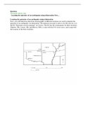
GEOG 1114 Physical Geography - Oklahoma State University. Locating the epicenter of an earthquake using trilateration _ Identifying volcanic hazards during a simulated eruption
- Exam (elaborations) • 9 pages • 2023
- $14.99
- + learn more
GEOG 1114 Physical Geography - Oklahoma State University. Locating the epicenter of an earthquake using trilateration Now, you will learn how data from seismographs in different locations are used to pinpoint the epicenter of an earthquake via trilateration. The material you need to refer to for this activity is in the file "Epicenter exercise package" on Canvas. The file has the seismograms for three locations (Marlow, OK, Carrier, OK, and Bolivar, MO), a scale with the P-S waves curve, and a...
-
ASBOG EXAM REVIEW PRACTICE QUESTIONS with correct answers.
- Exam (elaborations) • 26 pages • 2024
- $7.99
- + learn more
What does it mean when you have topographic contours on a 1:24,000 scale base map that are roughly circular and have hachures on the counters? - ANSWER-They represent a closed depression You have a base map at a scale of 1:6,000 and you need to represent the information you obtained during a field investigation of a site that is one square mile, that included mapping of your site as well as subsurface exploration results. What do you need to do to the map to make it work? - ANSWER-Use a large...
-
APES Unit 4 Study Guide Questions and answers, 100% Accurate.
- Exam (elaborations) • 7 pages • 2023
- $10.49
- + learn more
APES Unit 4 Study Guide Questions and answers, 100% Accurate. What are the layers of the earth? - -15; Crust, mantle, outer core and inner core What are the 3 major processes in Earths geologic cycle? - -Tectonic plates, rock cycle & soil formation Define the theory of plate tectonics - -The theory that the lithosphere of the earth is divided into plates, most of which are in constant motion Explain the movement of divergent plate boundaries and give an example - -An area beneath t...
