Arcgis desktop Study guides, Class notes & Summaries
Looking for the best study guides, study notes and summaries about Arcgis desktop? On this page you'll find 61 study documents about Arcgis desktop.
Page 4 out of 61 results
Sort by
-
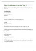
Esri Certification Practice Test 1 | 48 Question with 100 % correct answers | Verified
- Exam (elaborations) • 14 pages • 2023
- $7.39
- + learn more
Which two spatial query operators will select point features that are surrounded by polygon features? (Select two) A. Completely Contain B. Are Completely Within C. Share a Line Segment With D. Intersect E. Touch the Boundary Of - a,d Which limit is set for file geodatabase name length for ArcGIS Desktop? A. no limit B. limited to 32 characters C. limited to 255 characters D. limited to the number of characters the operating system allows in a folder name - c Which tool from the ArcG...
-
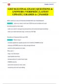
GIST 8132 FINAL EXAM | QUESTIONS & ANSWERS (VERIFIED) | LATEST UPDATE | GRADED A+ | PASSED
- Exam (elaborations) • 19 pages • 2024
- $11.49
- + learn more
When would you use an Enterprise Enabled Multi-user Geodatabase? ANSWER: - when you need a multi-user GDB that can be edited and used simultaneously by many users - when you need to manage long transactions and versioned-based workflows - when you need extremely large, continuous GIS DBs Describe an Enterprise Multi-user GDB ANSWER: *What it does:* - translate spatial/non-spatial queries from ArcGIS to RDBMS format - interacts w/RDBMS server for data storage/retrieval - performs GIS op...
-
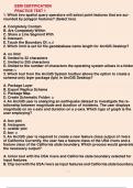
Esri Certification Practice Test 1 1. Which two spatial query operators will select point features that are surrounded by polygon features? (Select two) A. Completely Contain B. Are Completely Within C. Share a Line Segment With D. Intersect E. Touch the
- Exam (elaborations) • 11 pages • 2023
- $11.49
- + learn more
Esri Certification Practice Test 1 1. Which two spatial query operators will select point features that are surrounded by polygon features? (Select two) A. Completely Contain B. Are Completely Within C. Share a Line Segment With D. Intersect E. Touch the Boundary Of: a,d 2. Which limit is set for file geodatabase name length for ArcGIS Desktop?
-
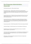
Esri Enterprise Administration Associate | Question with 100 % correct answers | Verified
- Exam (elaborations) • 6 pages • 2023
- $3.99
- + learn more
ArcGIS Enterprise licensing roles - Basic, Standard, Advanced Basic ArcGIS Server License - The Basic edition of ArcGIS GIS Server includes geodatabase management and the ability to publish feature services for map visualization and query (no editing). You also get the geometry service and the ability to publish geodata services. Portal for ArcGIS cannot be deployed. Standard ArcGIS Server license - All web service types. Web-enable maps and apps. Feature service editing and publish GP ser...
-
GIST 8132 DATABASE FINAL EXAM | QUESTIONS & ANSWERS (VERIFIED) | LATEST UPDATE | GRADED A+ | PASSED
- Exam (elaborations) • 26 pages • 2024
- $13.49
- + learn more
The top level version of the geodatabase is: A ) Editor B ) Parent C ) Default D ) Primary ANSWER: Default What can't you do when doing non-versioned editing? A ) Edit tables B ) Undo single operations C ) Use other applications to access data D ) Have multiple users ANSWER: Undo single operations Which table(s) contain(s) information on records added, deleted or updated in versioned editing? Deeagles - Stuvia US A ) Add and Delete B ) Spatial Index and Geometry Index ...

And that's how you make extra money

-
Esri Technical Certification: Sample Questions for ArcGIS Desktop Entry With Questions And 100% Sure Answers
- Exam (elaborations) • 13 pages • 2024
- $10.49
- + learn more
Esri Technical Certification: Sample Questions for ArcGIS Desktop Entry With Questions And 100% Sure Answers

-
GIS Final Exam 2023 Graded A Questions And Answers
- Exam (elaborations) • 7 pages • 2023
- $11.49
- + learn more
GIS - Computerized systems designed for the storage, retrieval, and analysis of geographically referenced data. ArcGIS - Advanced analysis and geoprocessing tools Map layer - Collection of geographic objects that are alike Vector data - Collection of points, lines & polygons Raster data - Matrix of identical square cells, formed into a grid 1. GIS - Computerized systems designed for the storage, retrieval, and analysis of geographically referenced data. 2. ArcGIS - Advanced ana...
-
Esri Certification Practice Test 1 | 50 Questions with 100% Correct Answers | Updated & Verified
- Exam (elaborations) • 15 pages • 2023
- $15.49
- + learn more
Which two spatial query operators will select point features that are surrounded by polygon features? (Select two) A. Completely Contain B. Are Completely Within C. Share a Line Segment With D. Intersect E. Touch the Boundary Of - a,d Which limit is set for file geodatabase name length for ArcGIS Desktop? A. no limit B. limited to 32 characters C. limited to 255 characters D. limited to the number of characters the operating system allows in a folder name - c
-
GIS Final Exam | 101 QUESTIONS AND ANSWERS 2023/24
- Exam (elaborations) • 5 pages • 2023
- $8.99
- + learn more
GIS Final Exam | 101 QUESTIONS AND ANSWERS 2023/24 GIS - Computerized systems designed for the storage, retrieval, and analysis of geographically referenced data. ArcGIS - Advanced analysis and geoprocessing tools Map layer - Collection of geographic objects that are alike Vector data - Collection of points, lines & polygons Raster data - Matrix of identical square cells, formed into a grid 1. GIS - Computerized systems designed for the storage, retrieval, and analysis of geographi...
-
GIS Final Exam 2023 Graded A Questions And Answers
- Exam (elaborations) • 7 pages • 2023
- $10.99
- + learn more
GIS - Computerized systems designed for the storage, retrieval, and analysis of geographically referenced data. ArcGIS - Advanced analysis and geoprocessing tools Map layer - Collection of geographic objects that are alike Vector data - Collection of points, lines & polygons Raster data - Matrix of identical square cells, formed into a grid 1. GIS - Computerized systems designed for the storage, retrieval, and analysis of geographically referenced data. 2. ArcGIS - Advanced ana...
