To faa ct 8080 2g figure - Study guides, Class notes & Summaries
Looking for the best study guides, study notes and summaries about To faa ct 8080 2g figure? On this page you'll find 25 study documents about To faa ct 8080 2g figure.
All 25 results
Sort by

-
FAA 107 Drone Pilot Test Questions
- Exam (elaborations) • 21 pages • 2024
- $12.49
- + learn more
FAA 107 Drone Pilot Test Questions 1 (Refer to FAA-CT-8080-2G, Figure 21.) What airport is located approximately 47 (degrees) 40 (minutes) N latitude and 101 (degrees) 26 (minutes) W longitude? – A. Mercer County Regional Airport. B. Semshenko Airport. C) Garrison Airport. (Refer to FAA-CT-8080-2G, Figure 26.) What does the line of latitude at area 4 measure? – A) The degrees of latitude east and west of the Prime Meridian. B) The degrees of latitude north and south of the equator. ...

-
FAA 107 Drone Pilot Test Questions
- Exam (elaborations) • 21 pages • 2024
- $12.49
- + learn more
1 (Refer to FAA-CT-8080-2G, Figure 21.) What airport is located approximately 47 (degrees) 40 (minutes) N latitude and 101 (degrees) 26 (minutes) W longitude? – A. Mercer County Regional Airport. B. Semshenko Airport. C) Garrison Airport. (Refer to FAA-CT-8080-2G, Figure 26.) What does the line of latitude at area 4 measure? – A) The degrees of latitude east and west of the Prime Meridian. B) The degrees of latitude north and south of the equator. C) The degrees of latitude east and ...
-
sUAS 318 Updated Questions With Answers|27 Pages
- Exam (elaborations) • 27 pages • 2024
- $9.99
- + learn more
__________ airspace (or Class G airspace) is the portion of the airspace that has not been designated as Class A, B, C, D, or E. - ️️Uncontrolled __________ areas contain airspace of defined dimensions within which the flight of aircraft is prohibited. Such areas are established for security or other reasons associated with the national welfare. - ️️Prohibited The keyword here is prohibited. Prohibited areas are published in the Federal Register and are depicted on aeronautical charts. ...
-
Final Exam Questions And Answers (Updated And Verified)
- Exam (elaborations) • 34 pages • 2024
- $13.49
- + learn more
Final Exam Questions And Answers (Updated And Verified) Air pressure in the atmosphere is typically measured in? centimeters (cm) inches of Mercury (Hg) feet - answerinches of Mercury (Hg) Under Part 107, if you want to fly a drone for commercial purposes, you are required to obtain... A private pilots certificate A remote pilot certificate with a small UAS rating An airline transport pilot certificate - answerA remote pilot certificate with a small UAS rating (Refer to Chart Suppleme...

Fear of missing out? Then don’t!

-
FAA 107 Drone Pilot Test Questions
- Exam (elaborations) • 21 pages • 2024
- $9.99
- + learn more
1 (Refer to FAA-CT-8080-2G, Figure 21.) What airport is located approximately 47 (degrees) 40 (minutes) N latitude and 101 (degrees) 26 (minutes) W longitude? – A. Mercer County Regional Airport. B. Semshenko Airport. C) Garrison Airport. (Refer to FAA-CT-8080-2G, Figure 26.) What does the line of latitude at area 4 measure? – A) The degrees of latitude east and west of the Prime Meridian. B) The degrees of latitude north and south of the equator. C) The degrees of latitude east and ...
-
FAA 107 Drone pilot test exam 2023 with 100% correct answers
- Exam (elaborations) • 22 pages • 2023
- $18.49
- + learn more
1 (Refer to FAA-CT-8080-2G, Figure 21.) What airport is located approximately 47 (degrees) 40 (minutes) N latitude and 101 (degrees) 26 (minutes) W longitude? - correct answerA. Mercer County Regional Airport. B. Semshenko Airport. C) Garrison Airport. (Refer to FAA-CT-8080-2G, Figure 26.) What does the line of latitude at area 4 measure? - correct answerA) The degrees of latitude east and west of the Prime Meridian. B) The degrees of latitude north and south of the equator. C) The degre...

-
Final Exam Questions And Answers (Updated And Verified)
- Exam (elaborations) • 34 pages • 2024
- $13.49
- + learn more
Final Exam Questions And Answers (Updated And Verified) Air pressure in the atmosphere is typically measured in? centimeters (cm) inches of Mercury (Hg) feet - answerinches of Mercury (Hg) Under Part 107, if you want to fly a drone for commercial purposes, you are required to obtain... A private pilots certificate A remote pilot certificate with a small UAS rating An airline transport pilot certificate - answerA remote pilot certificate with a small UAS rating (Refer to Chart Suppleme...

-
FAA 107 Drone Pilot Test Questions
- Exam (elaborations) • 21 pages • 2024
- $10.32
- + learn more
FAA 107 Drone Pilot Test Questions 1 (Refer to FAA-CT-8080-2G, Figure 21.) What airport is located approximately 47 (degrees) 40 (minutes) N latitude and 101 (degrees) 26 (minutes) W longitude? – A. Mercer County Regional Airport. B. Semshenko Airport. C) Garrison Airport. (Refer to FAA-CT-8080-2G, Figure 26.) What does the line of latitude at area 4 measure? – A) The degrees of latitude east and west of the Prime Meridian. B) The degrees of latitude north and south of the equato...
-
FAA PART 107 PRACTICE EXAM QUESTIONS 2024 WITH 100% VERIFIED ANSWERS LATEST UPDATE
- Exam (elaborations) • 33 pages • 2024
- $13.49
- + learn more
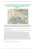
FAA PART 107 PRACTICE EXAM QUESTIONS 2024 WITH 100% VERIFIED ANSWERS LATEST UPDATE 1 (Refer to FAA-CT-8080-2G, Figure 21.) What airport is located approximately 47 (degrees) 40 (minutes) N latitude and 101 (degrees) 26 (minutes) W longitude? A. Mercer County Regional Airport. [This is definitely not even close. This airport is in the low minutes of 47 degrees North.) B. Semshenko Airport. [Ah yes, this is a close private airport. You can tell it is private because of the Pvt. Careful mea...
