100% tevredenheidsgarantie Direct beschikbaar na betaling Zowel online als in PDF Je zit nergens aan vast
logo-home
Samenvatting/cursus: Introduction to GIS (Theory) €6,99
In winkelwagen

Samenvatting

Samenvatting/cursus: Introduction to GIS (Theory)

 23 keer bekeken  1 keer verkocht

Samenvatting op basis van 15 mogelijke examenvragen voor het theorie-examen van Introduction to GIS. Iedere vraag wordt beantwoord alsook achtergrondinformatie om de context van de vraagstelling te begrijpen.

Voorbeeld 3 van de 30  pagina's

  • 17 juni 2021
  • 30
  • 2020/2021
  • Samenvatting
Alle documenten voor dit vak (1)
avatar-seller
xaviercornips
Exam questions GIS
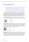
1. Describe the typical distortion pattern of azimuthal, cylindrical
and conical map projections and explain for which type of areas
each of the three classes of map projections is most suited.
What would be the best choice of map projection for a large-
scale topographic map of Portugal? Explain why. [could also be
another type of application and/or another country/region]
Map projections: Different approaches exist for projecting the curved Earth’s surface on a
map. The whole idea is to reduce distortion that will occur. The most simple approaches
project the mathematical model of the Earth (sphere, reference ellipsoid) onto a plane,
cylinder or cone touching the globe in one of the poles, along the equator, or along a chosen
parallel respectively. We speak of azimuthal, cylindrical and conical map projections.

Planar or azimuthal projections: The most simple way to project a part of the earth on a
plane is by taking a planar surface and letting that planar surface touch the globe in the pole.


Cylindrical projections: A second thing we can do, is making use of a cylinder, we can wrap
that cylinder around the globe, in such a way that it touches the sphere or the ellipsoid along
the equator. If we then put ourselves in the middle of that sphere, and you project each
point on the surface of the sphere into the cylinder, when you then cut the cylinder open
along a line parallel to its axis, we get a cylindrical projection.


Conical projections: The third thing we can do is wrap a cone around the sphere, in such a
way that it touches the sphere along one particular line of equal latitude, along one parallel.
Then again, we can project from a projection point which we can choose in different
locations but the simplest is that you would put it in the middle of the globe. If you then
project each point on the earth surface on the cone & we open up the cone along a line


Xavier Cornips 1

,parallel to its axis, then you obtain a conical representation of the earth.


! These 3 examples are examples of map projections where the body on which we project
touches the globe either in a point or along a line. For azimuthal projections in a point, in this
case the north pole. For cylindrical and conical projections along the equator or along one
line of equal latitude.

Each of these three types of map projection is characterised by its own typical distortion
pattern. There will be no distortion on the map in points or along lines where there is direct
contact between the plane, cylinder or cone and the globe (ellipsoid):

Azimuthal projections: no distortion in the pole - if you move away from the pole in all
directions along the meridians, distortion in the map will systematically increase. For what
kind of mapping applications, this map would be a good map projection type? It would be a
good mapping projection for the mapping of areas that are located close to the North pole.
The more you move away from the pole, the more distortion there will be in your map
reference system. An azimuthal projection is mostly for mapping polar areas.


Cylindrical projections: no distortion along the equator - since the cylinder is wrapped
around the equator, there is a perfect contact between equator and the cylinder in the
mapping process. If you unfold a cylinder, the equator will be represented by a line which
will have its correct length, however if you project from the centre of the earth, each point
of the globe into the cylinder, there will be
distortion. This distortion will increase if you
move away from the equator. So, for a
cylindrical projection, you have a distortion
pattern that increases away from the equator.
For what type of applications would you use
this kind of projection? If we would like to
represent an area close to the equator and


Xavier Cornips 2

, map it, this would be a perfect type of map projection. A cylindrical projection is mostly for
mapping equatorial areas.

Conical projections: no distortion along a
chosen parallel - There is a perfect connection
between the cone and the surface of the
earth. Along the parallel, where the cone
touches the globe. If you cut open or fold it,
we get a fan-shaped representation. The
parallel of contact will be represented in a
correct length; there will be no distortion. If
we move away from this line, along the meridians to the North and to the South, distortion
will increase. For what type of applications would you use this kind of projection? If we
would like to represent an area, that is located not at the equator or at the poles, but
somewhere else, but somewhere mid latitude, we would use a conical projection. You would
make sure that you would let the line touch the globe along a parallel that goes right
through the area which you would like to map. Because this is the zone of the map in which
distortion will be the lowest.

What we now did was just letting the projection plane touch the globe (tangent projection)
but we can also let it intersect the globe (secant projection).


Also, you can reduce distortion in several directions:


You can not only do this with a cylindrical projection but also with the other two types.


Xavier Cornips 3

Voordelen van het kopen van samenvattingen bij Stuvia op een rij:

√  	Verzekerd van kwaliteit door reviews

√ Verzekerd van kwaliteit door reviews

Stuvia-klanten hebben meer dan 700.000 samenvattingen beoordeeld. Zo weet je zeker dat je de beste documenten koopt!

Snel en makkelijk kopen

Snel en makkelijk kopen

Je betaalt supersnel en eenmalig met iDeal, Bancontact of creditcard voor de samenvatting. Zonder lidmaatschap.

Focus op de essentie

Focus op de essentie

Samenvattingen worden geschreven voor en door anderen. Daarom zijn de samenvattingen altijd betrouwbaar en actueel. Zo kom je snel tot de kern!

Veelgestelde vragen

Wat krijg ik als ik dit document koop?

Je krijgt een PDF, die direct beschikbaar is na je aankoop. Het gekochte document is altijd, overal en oneindig toegankelijk via je profiel.

Tevredenheidsgarantie: hoe werkt dat?

Onze tevredenheidsgarantie zorgt ervoor dat je altijd een studiedocument vindt dat goed bij je past. Je vult een formulier in en onze klantenservice regelt de rest.

Van wie koop ik deze samenvatting?

Stuvia is een marktplaats, je koop dit document dus niet van ons, maar van verkoper xaviercornips. Stuvia faciliteert de betaling aan de verkoper.

Zit ik meteen vast aan een abonnement?

Nee, je koopt alleen deze samenvatting voor €6,99. Je zit daarna nergens aan vast.

Is Stuvia te vertrouwen?

4,6 sterren op Google & Trustpilot (+1000 reviews)

Afgelopen 30 dagen zijn er 50843 samenvattingen verkocht

Opgericht in 2010, al 14 jaar dé plek om samenvattingen te kopen

Start met verkopen
€6,99  1x  verkocht
  • (0)
In winkelwagen
Toegevoegd