Freya Elizabeth Patten
The New Forest in 2069: The Future Impacts of Weather On the Human Population
The future is unknown now more than ever. Climate unable to hold changes in weather, and hence the
change is causing the weather to be unknowable, yet increases in extreme weather due to climate change are
changeable- all depending on us. The increase in causing the forest to be unable to cope. With this in
temperature is causing all types of weather to become mind, how will the New Forest (and the residents who
more extreme- and more dangerous. These affect the live there) cope with the changing weather?
human population in multiple ways such as inability to
travel, health problems to do with heat increase,
investment to property, and general loss of happiness or
wellbeing. The New Forest has always been affected by
human impacts ever since the Iron Age when there was
a continuation of woodland clearance. The A31 follows
a Roman route along the New Forest, materials
exploited for the production of pottery, clay, charcoal,
and fuel. One of the largest human impacts on the New
Forest occurred during the First World War when about
230,000 tonnes of timber were felled from the New
Forest. Oil refineries were established in Fawley in
1921, as well as World War 2 constructing major
airfields in parts of the forest. The forest was used as the
Figure 2: this historic area shows Brockenhurst in the 1930’s. there has
prime preparation site for D Day invasion and hence the obviously been an overflow in the local river Lymington river.
roads had to be widened with building programmes (NewForestGuide.co.uk)
everywhere.
Due to climate change and the extreme weathers,
flooding is becoming more of a frequent occurrence in
the UK. The New Forest holds large areas of heathland
and marshes, where there is likely to be a higher
increase in the number of floods. Due to the New Forest
being in the south region of the UK, there are fewer
floods recorded compared to the UK (the majority in the
midlands), yet there were areas of monitoring where
flooding is possible, such as in Bickery Mill Stream on
the outskirts of the New Forest (Gov.uk, 2019). The
history of floods in the New Forest show areas of
Brockenhurst severely flooded throughout the whole
area of Culverley Green to Waters Green. Figure 2
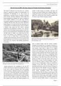
Figure 1: this shows D-day preparations in Brockenhurst, by widening shows an area of Brokenhurst which was affected by
the bridge to enable tanks to pass. (Newforestguide.com)
flooding in the 1930s. Due to the high levels of
Luckily, protection was established in the late 20th heathland and marshes in the New Forest, flooding has
century. The Forestry Commission manages the Crown always been an issue, though, in 50 years, alternative
Land, and in 2005 the National Trust took multiple factors will cause an increase in flooding. With sea
sections to protect. Biological aspects were established levels rising, Lymington floods will increase
such as New Forest pony-grazing, wild herds of deer, dramatically due to the city being a coastal region. This
and natural species competition- which without them, is also reflected in Christchurch (Data.gov.uk). Due to
open heathland and lawns would turn to shrub with pine the New Forest being in the coastal region, it will feel
and silver birch rapidly invading the heathlands. All the impacts of rising sea levels. The PICC predicts 0.6
these impacts have caused the natural ground to be metres rise, and the SARC estimate 1.4 metres increase
Page | 1
, Freya Elizabeth Patten
The average days hold (Greenwood, occurring in the New Forest. Since 1923 when the
precipitation of 13 mm in 2015). The maps forestry commission was put in charge of the forests
January and December, with in Figure 3 show 26,000 hectares of land, the national trust owns sectors
6mm in July and August. the New Forest if of the common land of around 1600 hectares- known as
This range shows that the the Greenland the Northern Commons. These are well protected and
New Forest had no month icecaps melt, hence there isn’t an increase in infrastructure in this
with no precipitation or rain which is the region (NationalTrust, 2019).
fall in 2018 (Mereorologisk equivalent of 6 Another issue is the percentage of the population in the
institutt, 2019). metres. New Forest which are over the ages of 65. This could
Lymington and cause problems when weather extremes occur, due to
Christchurch are affected the most, as well as the right- the lack of mobility or support for the older generations.
hand side near Hythe losing lots of land. Due to the This increase is reflected by the increase in the
increase in floods in the future of the New Forest, the population mean. (page 3) (Gov.uk aging profile).
biological structure will obviously change because of WHO states that the most developed world countries
the increase of water in the soil. The New Forest soil have the chronological age of 65 as a definition of the
already holds generally poor quality due to the clay and
sand- more flooding won’t help the case for
Figure 3: what England will look like if the Greenland Icecaps melt
(Nevett. J, 2019)
environmentally healthy land (NewForestGuide, 2017). Figure 4: this map shows the areas of UK with population aged
over 65. (Doughty. S, et al, 2012). This shows that the new forest
The human population will find it increasingly difficult is one of the highest regions with 25-30% of people aged over 65
to travel and get around if the roads are flooded. Some in 2011.
roads may be permanently closed and hence routes to
work and leisure may be affected. More infrastructure elderly (page 4). In 1851, the 65 and above population
causes some of the land to be demolished, causing would’ve been relatively small at 18,260 people- 5/25th
natural barriers to be torn down, which could very easily of the population (page 4), and this figure has gradually
lead to an increase in flooding. Increased housing increased in the percentage of elderly- not only in the
developments or roads puts stress on the environment New Forest, but in the World (as shown in figure 4).
and the surroundings. The government also has a high Most of the elderly in Hampshire are in the New Forest
influence on the protection and conservation of the New predominately (page 10). If the sea levels rise, causing
Forest which could cause dilemmas for the human flooding in 50 years, this area of the population will be
population. Due to the New Forest dating back 1,000 dramatically affected due to the housing development
years, the government and forestry commissions are being predominantly bungalows for this generation.
obviously very strict on building and production
Page | 2