AS
Geography
Notes
(Physical)
Unit
1:
Processes
that
shape
fluvial
environments
1. Closed
system-‐
a
system
with
inputs,
transfers,
processes
and
outputs
of
energy
but
not
matter
E.g.
hydrological
cycle
Earth
contains
water
in
all
states
(gas,
solid
and
liquid).
No
water
is
added
from
the
atmosphere
and
none
lost
so
it
is
a
closed
system
as
no
gains
or
losses
from
outside
the
global
system
necessary
for
system
to
function.
(Energy
comes
in
from
the
sun
but
this
is
not
matter).
Instead
water
is
cycled
between
oceans,
land
and
the
atmosphere
in
process
known
as
hydrological
cycle
2. Open
system-‐
a
system
with
inputs
and
outputs
of
both
energy
and
matter
Inputs
Boundary
Outputs
Material
Transfers:
flows
of
material
and
energy
within
the
system
Material
and
Stores:
places
in
the
system
where
material
and
energy
are
and
energy
energy
temporarily
stored
Feedback
Feedback-‐
when
opposing
forces,
inputs
and
outputs
balanced,
system
is
in
state
of
equilibrium
(normal
state
for
a
landform
system
e.g.
drainage
basin).
Feedback
is
a
mechanism
that
restores
the
balance
if
equilibrium
is
changed
e.g.
a
river
channel
may
naturally
enlarge
to
cope
with
a
greater
precipitation
input.
Inputs-‐
energy
or
matter
that
enters
into
the
system
(includes
precipitation
and
weathered
rock
or
sediment)
Outputs-‐
energy
or
rock
that
leaves
a
system
(includes
river
flow
or
evapotranspiration
and
sediment
washed
out
to
sea)
Stores-‐
natural
reservoirs
of
water
in
the
environment
such
as
lakes,
vegetation
and
soil.
Transfers/flows-‐
paths
that
water
follows
in
the
land
based
part
of
hydrological
cycle
(includes
flows
through
soil
e.g.
infiltration
and
channel
flow
in
rivers)
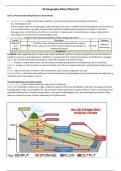
The
drainage
basin
as
an
open
system
Drainage
basin-‐
area
of
land
drained
by
a
river
and
its
tributaries
Watershed-‐
boundary
marked
by
a
ridge
of
high
land
beyond
which
any
precipitation
will
drain
into
adjacent
basins
Drainage
basin
relies
on
atmosphere
for
input
of
water
whilst
water
leaves
system
either
to
return
to
atmosphere
or
coastal/ocean
systems.
A
single
drainage
basin
is
one
part
of
hydrological
cycle,
but
hydrological
processes
taking
place
are
mostly
the
same
as
those
operating
at
the
global
scale.
,Drainage
basin
processes
above
the
surface
Input:
Precipitation-‐
the
deposition
of
water
in
either
liquid
or
solid
form
usually
reaches
earth’s
surface
from
clouds
in
the
atmosphere
and
includes
rain,
hail,
sleet,
snow,
dew
and
frost.
v 1%
of
precipitation
hits
river
directly
as
channel
catch,
while
rest
passes
through
transfers
v Main
characteristics
that
affect
local
hydrology:
amount,
type,
intensity,
seasonality
(frequency)
and
spatial
variation.
E.g.
In
British
Isles
areas
of
highest
precipitation
are
NW
while
lower
are
SE
v Drainage
basins
also
affected
by
when
and
how
often
rain
falls
(regime/seasonality
and
frequency).
Extreme
seasonality
occurs
in
monsoon
climates
with
one
wet
season
e.g.
India
v The
intensity
of
rain
affects
the
rout
taken
by
water
through
basin.
Steady
drizzle
has
intensity
less
than
moderate
rainfall
and
tropical
storms.
v The
form
of
precipitation
(rain,
hail,
sleet,
snow)
affects
the
system.
Snow
can
act
as
a
temporary
store
while
snowmelt
increases
flood
risk.
Storage:
Interception-‐
precipitation
caught
and
stores
on
the
leaves
and
stems
of
plants
• First
raindrops
fall
on
trees
and
plants,
which
shelter
ground.
Some
intercepted
water
will
evaporate
off
vegetation
and
return
to
atmosphere
store=
Interception
loss.
• Dry
plants
intercept
greatest
amount
of
precipitation
at
start
of
rainstorms.
Each
vegetation
type
has
storage
capacity.
In
forests
30%
rainfall
lost,
10%
in
grassland.
• As
leaves
become
wetter,
water
will
drip
to
ground
or
runoff
as
(transfer)
stemflow-‐
the
components
of
precipitation
input
that
have
been
intercepted
by
vegetation,
run
down
plants
surface.
• The
longer
duration
of
rainfall,
less
important
interception
loss
as
vegetation
stores
fill.
Light
rain
of
short
duration
means
more
evaporation
with
less
rainfall
reaching
earth.
• Amount
of
interception
depends
on:
duration,
intensity
of
storm
and
type
of
vegetation
cover.
Input:
Sediment-‐
particles
derived
from
rock
material
by
weathering
and
erosion
that
makes
its
way
into
a
river
system.
Output:
Sediment-‐
particles
derived
from
rock
material
by
weathering
and
erosion,
washed
out
to
sea.
Ø Sediment
is
both
input
and
output
Ø As
input,
it
is
produced
by
the
natural
processes
of
erosion
of
valley
sides
and
river
channel.
Increasingly
activities
of
man
are
adding
to
this,
leading
to
soil
and
rock
fragments
entering
river
channel.
Ø Sediment
may
be
stored
in
the
basin
e.g.
in
lakes
or
channel
bed
until
discharged
into
sea
as
sediment
yield
(tonnes/
sq.
km/
year).
As
it
leaves
drainage
basin
system,
it
becomes
an
output.
Precipitation-‐
heavy
rainfall
removes
soil
cover
Vegetation-‐
this
may
and
increases
sediment
yield.
Geology-‐
resistant
rocks
protect
soil
surface
e.g.
basalt
give
low
from
precipitation
and
sediment
yields.
Sands
and
reduce
erosion
silts
give
high
yields
The
amount
of
Human
activity:
good
soil
sediment
in
a
river
management:
such
as
contour
will
depend
on:
Human
activity:
deforestation
ploughing
or
terracing
may
and
mining-‐
expose
soil
to
erosion
decrease
sediment
yield
while
and
m ay
increase
sediment
yield
dams
and
reservoirs
reduce
the
movement
of
sediment
Output:
Evaporation-‐
the
process
by
which
water
is
changed
to
water
vapour
(gas)
by
molecular
transfer
Output:
Transpiration-‐
The
process
by
which
plants
loose
water
vapour
through
their
leaf
stomata
into
the
atmosphere
v Within
drainage
basins,
evaporation
occurs
from
intercepted
water
on
vegetation
surfaces,
bare
soil,
artificial
surfaces
and
w ater
surfaces
v Transpiration
can
only
occur
if
the
plants
have
supply
of
moisture
from
soil.
Many
plants
adapt
structures
or
annual
rhythms
of
leaf
fall
to
reduce
transpiration
rates
when
soil
water
may
not
be
available
e.g.
stomata
of
desert
plants
are
sunken,
leaves
of
some
plants
drop
off
in
dry
season
v Evaporation
and
transpiration
u sually
work
together
as
evapotranspiration.
Factors
that
influence
evapotranspiration:
1. Temperature-‐
hotter
temperatures
generate
more
evaporation
from
surfaces
and
plants
due
to
changing
liquid
water
to
vapour.
Therefore
desert
environments
will
have
greatest
evaporation
rates
2. Relative
humidity-‐
how
much
water
vapour
is
present
in
the
atmosphere.
If
high,
air
is
almost
saturated
with
water
vapour
so
evaporation
less
likely.
If
low,
air
is
dry
and
will
be
able
to
h old
more
water
vapour
released
through
evaporation
, 3.
Wind-‐
in
windy
conditions,
water
vapour
evaporated
from
plants
blown
away
from
surface
rapidly.
This
increases
possibility
for
more
evaporation
to
occur
4.
Soil
depth-‐
shallow
soil
will
hold
more
water
vapour
near
the
surface
so
will
release
more
through
evaporation
than
a
soil
that
retains
water
at
greater
depths.
Drainage
basin
at
and
below
the
surface
Transfer:
infiltration-‐
the
downward
movement
of
water
from
rainfall
or
snowmelt
into
the
soil.
• Hydrologists
study
this
by
measuring
infiltration
rate-‐
amount
of
water
passing
through
the
soil
in
a
certain
time
• Also
measure
infiltration
capacity-‐
maximum
rate
at
which
a
particular
soil,
under
specific
conditions
can
absorb
precipitation.
I.e.
how
much
water
can
pass
through
a
given
unit
of
soil
in
a
certain
time
(cubic
mm
/
hour)
• A
key
process
as
precipitation,
which
arrives
at
the
surface
but
does
not
infiltrate
is
likely
to
run
off
quickly
into
streams
and
rivers
as
overland
flow.
(The
soil
may
be
washed
away,
causing
erosion)
Factors
affecting
the
amount
of
infiltration:
(important)
1. Intensity
of
precipitation-‐
great
intensity
(downpour)
less
likely
to
infiltrate
than
low
intensity
(drizzle)
2. Vegetation
cover-‐
vegetation
helps
break
up
soil,
increasing
air
space,
which
water
can
infiltrate
3. Angle
of
slope-‐
water
will
run
off
steeper
slope
more
easily
than
gentle
slope.
Quicker
water
runs
off,
less
likely
to
infiltrate
4. Nature
of
soil
and
rock
type-‐
size
of
soil
and
rock
particles,
amount
of
air
space
and
cracks
affect
infiltration.
Sandy
soil
has
larger
particles
and
more
air
spaces
than
clay
soil,
encouraging
infiltration
5. Depth
of
water
table-‐
if
near
to
surface,
soil
will
become
quickly
saturated
and
less
infiltration
will
occur
6. Time-‐
if
rainfall
occurs
over
long
time,
infiltration
will
decrease
as
soil
store
fills
up
i.e.
high
antecedent
moisture
conditions.
Transfer:
Throughflow-‐
the
downslope
movement
of
water
due
to
effects
of
gravity
and
decrease
in
infiltration
capacity
of
the
soil
with
increasing
depth.
Soils
become
more
compacted
in
depth
because:
there
are
fewer
spaces
and
cracks
in
the
lower
soil
horizons
and
less
plant
root
penetration
occurs,
which
opens
up
the
soil.
Throughflow
is
generally
a
slow
process
(unless
root
systems
penetrate
and
animals
burrow)
movement
ranging
between
0.01mm
and
1mm
/
minute.
Transfer:
Percolation-‐
process
by
which
water
moves
downwards
through
rock,
often
used
for
deeper
movement
below
water
table.
v Water
that
percolates
becomes
part
of
groundwater
store.
v Rocks
vary
greatly
in
amount
of
water
they
can
hold.
A
rock
that
holds
water
in
pore
spaces
in
called
porous.
Porosity-‐
the
amount
of
air
spaces
in
a
rock
or
soil,
and
is
a
measure
of
the
amount
of
water
a
rock
could
contain.
Water
bearing
rocks
like,
Limestone,
chalk
and
sandstones
are
very
porous
and
contain
a
lot
of
groundwater.
They
are
called
aquifers.
v Pervious
rocks
have
closely
packed/
interlocking
grains
and
water
can
be
stored
or
move
through
the
joint,
cracks
and
bedding
planes.
v Porous
and
pervious
rocks
are
called
permeable
rock
if
pores
and
cracks
join
up
and
let
water
pass
through.
Some
rocks
are
impermeable-‐
don’t
let
any
water
pass
through.
They
stop
groundwater
flow
and
are
called
aquicludes.
v Water
collects
above
impermeable
rock
layer
or
may
fill
all
pores
paces.
This
creates
a
zone
of
saturation.
Its
upper
boundary
is
known
as
the
water
table.
Deep
in
bedrock,
water
transferred
as
groundwater
flow/
base
flow.
v Groundwater
levels
usually
respond
slowly
to
surface
storms
or
short
periods
of
drought
(except
in
areas
of
carboniferous
limestone).
During
long
dry
period,
some
of
groundwater
store
will
be
used
as
river
levels
fall.
In
subsequent
wetter
period,
groundwater
must
be
replaced
before
river
level
can
rise
appreciably.
Transfer:
Overland
flow/
surface
runoff-‐
the
component
of
precipitation
input
which
is
transferred
to
channel
by
movement
across
the
ground
surface.
Ø Water
which
cannot
infiltrate
collects
on
ground
surface
in
hollows
and
depressions
as
depression
storage.
Ø If
these
fill
up,
water
may
flow
over
surface
as
overland
flow/
surface
runoff.
Vegetation
covered
surfaces
have
high
infiltration
capacity
so
overland
flow
is
rare
in
natural
conditions.
More
common
when:
ground
surface
is
frozen
in
winter,
ground
has
dried
leaving
a
surface
crust
or
there
is
a
violent
rainstorm.
Ø Human
activities
that
increase
soil
compaction
and
overland
flow
include:
passage
of
farm
machinery
and
trampling
by
animals.