Unit
3:
River
environments
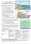
Water
(hydrological)
cycle-‐the
natural
process
whereby
water
is
continuously
circulated
between
air,
land
and
sea
Closed
system
so
total
amount
never
changes
Precipitation-‐
a
tern
used
to
describe
rain,
snow,
hail
and
sleet
(input)
Interception-‐
precipitation
caught
and
stored
on
the
leaves
and
stems
of
plants
(storage)
Evaporation-‐
the
sun’s
energy
heats
surface
water
and
changes
it
to
water
vapour
(output)
Surface
runoff/
overland
flow-‐
water
flows
over
the
ground
surface
towards
the
river
channel
(storage)
Infiltration-‐
the
downward
movement
of
water
into
the
soil
from
the
ground
surface
(flow/transfer)
Transpiration-‐
the
release
of
water
vapour
from
plants
(output)
Throughflow-‐
the
sideways
movement
of
water
through
the
soil
(flow/transfer)
Percolation-‐
the
downward
movement
of
water
into
underlying
rocks
(flow/transfer)
Groundwater
flow-‐
the
sideways/
lateral
movement
of
water
deep
underground
through
rocks
(flow/transfer)
Drainage
basin-‐
the
area
of
land
drained
by
a
river
and
its
tributaries
It
is
an
open
system
with
inputs,
outputs,
transfers
and
stores
Source-‐
the
origin
of
a
river
in
upland
areas
e.g.
snow
melt
or
marsh
land
Confluence-‐
where
two
or
more
tributaries
meet
River
mouth-‐
where
the
river
meets
the
sea
or
a
lake
Tributary-‐
streams
which
drain
into
the
main
channel
Watershed-‐
the
high
ridge
of
land
forming
the
boundary
of
the
drainage
basin
River
discharge-‐
the
amount
of
water
passing
any
point
in
a
river
at
a
certain
time,
normally
given
as
cubic
metres
of
water
per
second
(cumecs)
Evapotranspiration-‐
water
is
transferred
to
the
atmosphere
as
water
vapour
from
land
surfaces
and
vegetation
(evaporation
and
transpiration)
River
processes
and
landforms
How
the
long
profile
of
a
river
changes
through
the
upper,
middle
and
lower
course
Upper
course
Middle
course
Lower
course
Characteristics
Waterfalls,
steep,
Meanders,
erosion
and
Estuaries,
flat,
floodplains,
deposition,
steep
valley,
deposition,
flood
plains,
delta,
widest,
fastest
&
rapids
lakes,
faster,
wider
&
deepest
channel
deeper
channel
Description
River
uses
weathering
and
River
starts
to
meander
River
meanders
over
wide
erosion
to
erode
cutting
from
side
to
side
to
floodplain
in
S-‐shaped
downwards
in
the
hills
to
erode
the
valley.
Some
curves.
Deposition
of
form
a
v-‐shaped
valley.
erosion
at
river
cliffs.
alluvium/silt
across
Channel
is
thin
and
shallow
Floodplains
start
to
form.
floodplain.
Flood
plain
flat
Channel
is
deeper
and
and
wide.
Channel
deep
wider
and
wide
How
do
river
variables
change
downstream?
-‐
Curly
Burn
River
Fluvial
characteristics
such
as
width,
depth,
discharge,
load,
gradient
change
as
we
follow
the
river
source
to
mouth.
We
would
want
to
carry
out
a
systematic
sample.
Collecting
data
at
regular
intervals
normally
1km
in
the
upper,
middle
and
lower
course
to
see
how
the
river
changes.
, Upper
course-‐
lots
of
vegetation,
slow
flowing
water,
steep
gradient,
narrow
river
channel,
shallow
water,
steep
river
bank,
large
boulders/bed
load
Middle
course-‐
less
steep
gradient,
more
discharge,
meander,
wider
river
channel,
fast
flowing,
deposition,
deeper
water,
smaller/more
rounded
bed
load
Lower
course-‐
flat
gradient,
can
be
deposition,
small
rounded
bed
load,
look
clam,
fast
flowing
(less
friction),
deep,
more
discharge,
wide
river
channel,
can
be
deposition.
Width-‐
clear
positive
correlation
as
distance
increases
from
upper
to
lower
course,
width
of
the
river
also
increases
Depth-‐
strong
positive
correlation
as
distance
from
stream
increases
from
upper
to
lower
course,
depth
of
river
increases
Discharge-‐weak
positive
correlation
as
distance
downstream
increases
from
upper
to
lower
course,
discharge
increases
Load-‐
strong
negative
correlation
as
distance
downstream
increases
from
upper
to
lower
course,
load
decreases
Gradient-‐
clear
negative
correlation
as
distance
downstream
increases
from
upper
to
lower
course
gradient
decreases.
Data
collection
Width-‐
measured
by
placing
one
end
of
a
measuring
tape
at
one
side
of
the
river
channel
(top
of
flowing
water)
and
other
end
stretched
across
to
other
bank.
Watch
out
for
rats.
(Metres)
Depth-‐
measured
by
lowering
metre
sticks
into
river
every
10th
of
the
way
across
river
and
distance
from
the
water
surface
to
the
riverbed
recorded
in
metres.
Average
depth
calculated
and
cross
section
can
be
drawn
(cm/mm)
Discharge-‐
is
amount
of
water
passing
any
point
in
a
river
at
a
certain
time,
normally
given
as
cubic
metres
of
water
per
second,
cumecs.
Multiply
cross
sectional
area
of
the
river
at
a
certain
point
by
the
speed
(velocity)
at
the
same
point.
Cross
sectional
area:
multiply
width
of
river
by
average
depth.
Speed:
using
digital
flowmeter,
has
a
propeller,
giving
speed
of
flow
(use
stick).
E.g.
width=6,
average
depth=
0.5,
speed=
2m/s,
discharge=
6x0.5x2=
6
cumecs.
Means
that
6
cubic
metres
if
water
will
flow
past
a
point
on
the
bank.
Gradient-‐
a
measure
of
how
steeply
it
loses
height.
Put
2
poles,
10m
apart
in
the
river.
Use
clinometer
to
measure
angle
between
eye
level
on
both
poles.
Steeper
the
angle,
steeper
the
gradient
(degrees)
Load-‐
the
material
it
is
carrying
from
small
sediment
to
large
boulders.
Easiest
to
measure
bed
load:
measure
longest
axis
of
15
random
or
systematically
sampled
rocks
at
each
point,
an
idea
of
size
of
load
is
obtained.
Each
stone
is
given
rating
for
roundness
1
is
very
angular
and
5
is
well
rounded.
Erosion-‐
wearing
away
of
the
bed
and
banks
of
the
river,
removing
particles
from
the
landscape.
Vertical
erosion-‐
when
rivers
have
large
coarse
bed
load
which
scrapes
and
rubs
against
river
bed,
eventually
lowering
the
bed
and
creating
steep
valley
sides
Lateral
erosion-‐
where
the
river
flows
fast
(further
downstream),
the
water
has
enough
energy
to
wash
away
the
bank
of
the
river
leading
to
undercutting
and
collapse
Corrasion/
Abrasion-‐
this
is
the
grinding
of
rock
fragments
carried
by
the
river
against
the
bed
and
banks
(sandpaper
action).
This
causes
the
channel
to
widen
and
deepen
by
dislodging
more
particles.
It
happens
most
during
flood
conditions
Attrition-‐
collision
of
rock
fragments
in
the
river
against
one
another
as
they
move
downstream.
The
stones
are
broken
into
smaller
pieces
and
become
smoother
the
longer
the
process
continues.
Solution/
Corrosion-‐
process
by
which
weak
acid
chemicals
in
the
river
react
with
the
rock
and
dissolve
soluble
minerals.
It
often
happens
in
limestone
areas
Hydraulic
action-‐
this
is
when
the
force
of
moving
water
pounds
into
the
riverbed
and
banks,
dislodging
more
material.
Transportation-‐
when
eroded
material
in
the
river
is
carried
from
one
place
to
another
through
the
river
system.
Large
Traction-‐
when
the
heaviest
particles
of
eroded
material
are
rolled
along
the
riverbed.
Usually
these
stones
and
boulders
can
only
be
moved
when
the
river
has
a
large
volume
of
water
in
it
Saltation-‐
some
of
the
heavier
particles
are
not
held
up
in
the
flow
of
the
river
all
of
the
time,
instead
to
they
may
be
bounced
along
the
riverbed.
Suspension-‐
as
the
speed
of
water
increases,
the
river
is
able
to
pick
up
larger
particles
and
stones
in
its
flow,
when
the
particles
are
carried
along
in
the
flow
of
the
water
and
do
not
make
contact
with
the
river
bed,
they
are
suspended
within
the
river