TECTONICS CONTENT SUMMARY
EQ1
Constructive Boundary: When plates move apart – magma wells
up to fill the gap – creates new crust – i.e., the Atlantic Ocean Sea
floor spreading. Rift volcanoes are formed. These are ‘effusive’,
meaning less violent and usually occur underwater. The magma is
basaltic and has low viscosity, cooling quickly. High frequency,
shallow focus (not deep) earthquakes that are generally low
magnitude.
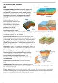
Destructive Boundary: When two
plates move towards each other. One
is pushed under the other, heavier
under the lighter one. Dense oceanic
meets continental crust, subducting
the oceanic crust under the
continental due to greater buoyancy,
forms a subduction zone. Creates
volcanoes as the melting crust adds to the mantle, increasing pressure which is releases by eruptions. Often forms
volcanic islands and trenches. Two continental collisions result in the
formation of mountains – i.e., The Himalayas.
Conservative/ Formation: When two plates slide against each other.
Neither is raised or lowered. Considered the most powerful. The movement
is HORIZONTAL, does not result in volcanic activity. Sites of shallow focus,
high magnitude earthquakes. Plates rub against each other, moving in
opposite directions or the same at different speeds, creating friction and
getting stuck, when this release occurs, violent earthquakes may occur.
Asthenosphere: Closer to the surface there is less pressure, allowing the
mantle to flow. This zone is ductile and what causes the plates to move.
Lithosphere: A layer composed of the crust and upper mantle –
approximately 100km deep. Always moving, but very slowly,
fuelled by rising heat from the mantle which creates convection
currents – Lithosphere and Asthenosphere are differentiated by
physical strength rather than physical composition. The
lithosphere is broken up into huge sections, these are known as
TECTONIC PLATES.
Oceanic Crust: Thin and VERY DENSE, comprised of primarily
Basalt.
Continental Crust: Thicker and LESS DENSE, comprised primarily of
Granite which is less dense than Basalt. Low density of the thick continental crust allows it to ‘float’ higher on the
high-density mantle below it.
Sea floor spreading: Occurs at constructive boundaries under the oceans – the continuous input of magma is what
formed the mid-Atlantic ridge. On land, a rift valley forms. Palaeomagnetism can be used to date the age of new
tectonic crust through the reconstruction of paleomagnetic reversals.
,Palaeomagnetism: Results from the zone of magma ‘locking in’ the Earth’s
magnetic polarity at the time of cooling. Can be used to determine historic
periods of large-scale tectonic activity through reconstruction of relative
plate motions and can be used to create a geo-timeline.
Hot Spots: Not all volcanoes occur
on plate boundaries. An example is
the Hawaiian Islands. An area within the mantle from where heat rises up as
a hot, thermal plume deep within the Earth. The high heat at the base of
the lithosphere melts it, and the magma rises through the cracks and erupt
to form active volcanoes at the surface. As plates move, these volcanoes
move too but the hotspot does not, forming new volcanoes, leaving behind
islands comprised of inactive volcanoes and produces atolls and sea mounts
(sea mountains).
Convection Currents: Rising plumes of magma reach the plates as they
rise to the plate they begin to cool. As it cools, it drags the crust along,
causing the plates to move. Because the magma is hotter and denser
it will rise.
Atolls: Ring shaped coral reefs – like the Maldives.
Seismic Waves: P waves are sounds that travel through rock. Particles are
alternatingly squished together and pulled apart (compressions and dilations)
so P waves are often called COMPRESIONAL waves and can travel through
solids, liquids, and gases. In S waves the rock particles slide past one another
and are sometimes called SHEER waves and travel forward with the particles
remaining in the same place, sliding back and forth past each other.
Measuring earthquakes: Magnitude and intensity. Magnitude measures the
amount of energy released at the epicentre. Scales such as the MMS (Moment
Magnitude Scale) is used to measure larger Earthquakes. Measures total energy
released by an earthquake at the moment it occurs (called a seismic moment),
using the:
▪ Size of the seismic waves
▪ Amount of slippage or rock movement
▪ Area of the fault surface broken by the earthquake
▪ Resistance of the affected rocks
The mantle is actually green – it is comprised of magnesium, iron, silicon, and oxygen. It is solid but hot, similar to a
putty, and is elastic. It can crack but is also ductile so can move and flow slowly.
Some EQs still occur along old fault lines. Scattered EQs along continental interiors, however most earthquakes occur
away from plate boundaries.
, EQ2
MHZ: Multiple Hazard Zone
Degg’s Model:
▪ Shows the interaction between hazards, disaster, and human vulnerability. A disaster may only occur when a
vulnerable population is exposed to a hazard.
Hazard: A perceived natural/ geographical event and has the
potential to threaten both life and or property
Disaster: The realisation of a hazard when it causes a
significant impact on the vulnerability of a population (Degg)
– The Centre for Research on the Epidemiology of Disasters
(CRED) states that a hazard becomes a disaster when deaths,
reduction to GDP, people impacted, and monetary loss
exceeds a certain threshold.


