Landscapes from the past Tectonic processes
Malham cove is found in the Yorkshire Pennines. It is an upland Over 300 million years, three tectonic processes affected
area. It is formed from limestone and consisted of crushed
rocks in the Pennines:
corals that lived in tropical seas 300 million years ago. The -The plate on which the UK sits shifted away from the tropics
landscape around Malham cove results from 3 factors:
-Convection currents beneath the plate uplifted rocks from
below the sea- becoming land
Geology -During uplift, some rocks snapped and moves along faults in
By testing fossils at Malham cove using carbon dating, geologists a series of earthquakes over thousands of years. Each
know that they lived 250-350 million years ago. movement disturbed the strata, so they tilted
At the time, the UK was covered by tropical seas. As tropical fish
and corals died, skeletons fell to the sea floor, forming horizontal Glaciation
layers (or strata). Two processes made them solid rock. As the Pennines were uplifted, rivers eroded into them,
->As skeletons fell, they crushed those beneath and squeezed creating V-shaped valleys. The most recent ice age
out water compacting them into rock. brought huge glaciers to the Pennines. Their effects:
->Calcium carbonate (which occurs naturally in sea water) -Altering river valleys, making them deeper and widening
crystallized around the fragments. This cemented them together them into U-shaped troughs
and even preserved some fossils. -As they melted, the glaciers left features like Malham
Cove with a waterfall.
Rocks formed in Carboniferous times vary in
hardness. The most resistant tock is millstone
grist. It resists erosion so well that it forms the
highest peaks of the Pennines and protects
weaker sands and shales beneath. The figure is
the geological cross section of a valley in the
Pennines.
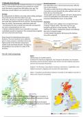
The UK’s relief and geology
Relief
Upland areas are mainly found in…
Scotland=The Northwest Highlands, the Cairngorm Mountains, the Grampian
Mountains and the Southern Uplands. Ben Nevis is the UK's highest peak and is
found in the Grampian Mountains.
England - The Pennines, Lake District, Dartmoor and Exmoor. Scafell Pike is the
highest mountain in England and is found in the Lake District
Wales - Snowdonia and the Brecon Beacons. Snowdon is the highest mountain in
Wales and is found in Snowdonia.
Geology
Igneous rocks can be found mainly in upland areas in Scotland, in
the Lake district in North West England and in Snowdonia in North
Wales and Northern Ireland
Metamorphic rocks are found in Northern Ireland and Scotland
Sedimentary rocks are widely found across lowland areas of England
, Rock types Rocks and landscape
The height and shape of the UK’s highlands and lowlands depend on the rocks Relief (landscape) depends greatly on rock type
from which they are formed. Britain’s geology is valuable:
-Cornwall has large amounts of tin and copper which made it wealthy
-Huge strata of coal helped to make Britain the world’s first industrial nation.
Other resources include building stone such as marble and raw materials such
as iron ore.
Types of rock
Igneous rocks = The Earth’s oldest rocks, formed from lavas and deep magmas
(volcanic activity from the past). They were once molten, then cooled and
crystallised. Most igneous rocks are resistant to erosion.
Sedimentary rocks = Formed from sediments (small particles) eroded and
deposited by rivers, the sea, or on the seabed. Over millions of years,
successive layers of sediments accumulate. Some are resistant while other
crumble easily.
Metamorphic rocks = Sedimentary rocks that were heated and compressed
during igneous activity. They have changed in shape and form by intense heat
and pressure causing them to harden and become resistant.
Upland and lowland landscapes
The lake district – An upland landscape
-The landscape is full of high mountains and low valleys due to glacial and
tectonic processes that have affected the area.
-In Cumbria which is in the northwest of England
Post-glacial river process:
The area was once glaciated. Glaciers created deep U-shaped valleys and
hollows now filled by lakes. Over time, the valleys filled up with water to
form lakes, and now many small rivers flow through the valleys (these
rivers are small compared to the valleys and are called misfits). The rivers
deposit slit and mud (known as alluvium) in the valley bottoms making
them fertile for farming
Weathering:
Rock fragments called scree make the ground rough. Scree consists of
angular rock pieces created by freeze-thaw weathering. Each winter,
temperatures are below freezing at night and warmer in the day.
Rainwater gets into cracks and expansion widens the cracks and
eventually the rock breaks into pieces.
Rapid slope processes: (affecting valley sides)
-Scree fragments are unstable and move easily during rockfalls,
increasing danger for walkers
-Landslides are common. The lake district is UK’s wettest region. Rain
adds to the weight of weathered rock, so it slides easily.
The Weald – A low landscape Weathering:
The Weald consist of undulating (gentle rolling) hills that are located at As southern England is warmer, different types of
much lower elevations, but still create distinctive landscapes. The Weald weathering occur:
was once a dome of folded rocks, forming a rock called an anticline. -Chalk is calcium carbonate, an alkali, and so is
Erosion has left alternate strata of more and less resistant rock to form a affected by solution/chemical weathering
landscape known as scarp and vale topography. -Tree and shrub roots break up solid rock (biological
-Resistant rocks, like chalk, form steep escarpments. weathering)
-Behind the escarpment, gentle slopes follow the angle at which the
rocks were tilted (called the dip), known as a dip slope. Post glacial river processes:
-Softer clays are lower and flatter, forming the vales. -It is unusual to find rivers in chalk areas, except when its
Slope processes: saturated after wet weather.
-Are slower than in the -But clay is impermeable, so rivers are common in vales.
Lake District -During the last Ice Age water in the chalk froze, making it
-the most common is soil impermeable. Then, fresh water formed rivers and valleys.
creep. It is caused by rain -As climate warmed, water seeped through the chalk once
dislodging soil particles. again leaving dry valleys where dry rivers had once flowed.