100% satisfaction guarantee Immediately available after payment Both online and in PDF No strings attached
logo-home
Summary Physical geography A level essay plans £5.79
Add to cart

Summary

Summary Physical geography A level essay plans

 11 purchases

This document provides an extensive list of essay plans for Geography A level according to the 2016 spec. Inside there are essay plans for coasts, water and tectonics, which cover many 4-20 markers. I achieved an A* in my exam and this was extremely useful for revision.

Preview 3 out of 27  pages

  • August 20, 2020
  • 27
  • 2018/2019
  • Summary
All documents for this subject (132)
avatar-seller
Hannahchloe
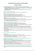
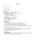
Geography A Level 2016 essay plans: 4,6, 8 and 20 markers

Tectonics: 4 markers

Explain two strategies that are used to modify vulnerability to volcanic hazards: (4)
1. Land-use Zoning: In areas at risk from volcanic eruptions, land-use zoning is an effective way to
protect people and property. In areas at high risk from volcanic eruptions, any settlements tend to
be limited and some communities may be resettled.
2. Diverting Lava Flows: Include building barriers and digging channels to try to divert the @lows
into safer directions,

DeJine what is meant by disaster: (4)
A sudden accident or a natural catastrophe that causes great damage or loss of life

Explain the formation of a tsunami: (4)
• Usually caused by volcanic eruptions or underwater earthquakes
• Tend to occur along plate boundaries - particularly the Paci@ic’s ‘Ring of Fire’
• Sometimes caused by underwater landslides or asteroid strikes
• Energy released during the earthquake causes the sea @loor to uplift - displacing the water column
above
• This displaced water forms tsunami waves
• Most tsunami waves are no higher than 3m but largest waves can reach 30m
• When the wave’s crest reaches the shore, it produces a vacuum effect- sucking the water back out to
sea and exposing a large amount of sea @loor
• The suddenly retreating water and exposed sea @loor is an early warning sign

Explain the ways people predict tsunamis (4)
• As they are caused by underwater earthquakes, they are dif@icult to predict
• Tsunami early warning systems are now in place in the Paci@ic and Indian Ocean
• Seismic sensors detect undersea earthquakes but not all cause tsunamis - scientists use additional
scienti@ic equipment to gather more information
• DART system: seabed sensors and surface buoys to monitor changes in sea level and pressure
• When tsunami waves detected, the system sends info via a satellite to tsunami warning stations
which review the transmitted info and use computer modelling to estimate the size and direction
Case Study: Japan
• When the magnitude 9.0 earthquake struck, the Japan Meteorological Agency issued a major tsunami
warning within 3 minutes
• But system failed - size of earthquake was underestimated which meant that the tsunami’s power
underestimated

Explain the causes of one earthquake (4)

Case study: Haiti
• Conservative plate boundary - the Caribbean and North American plates
• The North American Plate was moving west - this movement is not smooth and there was friction
between the N.A plate and the Caribbean plate
• Pressure built up between the two plates until it was released as an earthquake

Explain the value of Park’s hazard-response curve in understanding the management of the
impacts of tectonic Hazards (4)
• Shows how a country or region might respond after a hazard event
• Used to compare how areas at different levels of development might recover from a hazard event
• Impacts of a hazard event change over time - depending on factors such as size of the hazard,
development level and amount of aid received
• All hazards have different impacts so curves are different: hazard events that happen suddenly
(Haiti) and those that happen over a long period (Monsterrat)
• Wealthier countries have different curves to developing countries as can recover faster than them

Explain the link between plate boundary type and the strength of an earthquake wave: (4)
• Destructive plate boundaries cause intermediate and deep earthquakes in an area called the Benioff
Zone

,• Constructive plate boundaries cause very small earthquakes - magma, when it forces its way up
between two plates, fractures them slightly
• Conservative plate margin: two plates slide past each other, causing a major break in the crust which
is called a fault (transform fault on a large scale). Creates powerful earthquakes - two plates
sometimes stick as they move past each other - causing stress and pressure to build up, which is
suddenly released as a strong shallow-focus earthquake. E.g. San Andreas Fault.

Explain the correlation between the magnitude and intensity scales used for measuring
earthquakes and their secondary hazards (4)
• Earth scientists use two characteristics - magnitude and intensity - to measure earthquakes
• Magnitude measures the amount of energy released at the epicentre
• The Moment magnitude Scale
• Intensity: earthquake’s effect on people, structure and the natural environment
• Modi@ied Mercalli Intensity Scale: take observations from people who experienced the earthquake
and rates them on a scale from 1 to X11

Analyse the effectiveness of modifying the impacts of a tectonic hazards: (4)

Land-use Zoning: Diverting Lava Flows GIS Mapping Hazard Resistant
Design
• Local gov planners • Building barriers, • Used in all stages of • New buildings and
regulate how land in digging channels disaster management structures can be
a community may be • Have led to success cycle designed to resist
sued e.g. barriers and • Identify where ground shaking
• Areas at risk are channels successfully evacuation routes during earthquakes
divided into zones diverted a lava @low should be placed pr • Roofs of houses built
based on the likely from the 1983 help with reduce and near volcanoes
type and level of eruption of Mount recovery options sloped to reduce
damage from an Etna in Italy • Locations and rough amount of ash that
eruption population size of builds up - reducing
• Land-use planners major towns and risk of collapsing
use hazard maps to cities • Buildings at risk of
make decisions about • Areas affected by tsunamis can be
land-use earthquake elevated and
• laces which are at • Locations of airports anchored to
risk - settlements are and airstrips foundations
limited, certain types • Existing buildings
of structure, some modi@ied - retro@itting
communities to make safer e.g.
resettled, strengthening
development in areas foundations
which provide • Protective structures:
natural protection seawalls
limited (mangrove)
Negatives: Negatives:
• Land-use zoning • Usually are ineffective
common in wealthy • Path taken by lava is
countries, but less so hard to predict
in developing • Terrain has to be
suitable
• Stopping the lava
@lowing towards one
community may push
it towards another


Water 6 Markers:

Explain why land use changes can increase 3lood risk. (6)

, • Deforestation
• Dense forest vegetation intercepts & transpires nearly half of precipitation inputs
• Forest canopy intercepts rainfall & slows inputs as through fall
• Deforestation reduces interception & transpiration feedback = increased rates of surface runoff.
Exposes soils to greater rates of erosion - sedimentation of the channel, which reduces capacity &
• Urbanisation:
• Urbanisation leads to impermeable surfaces. Rainfall cannot in@iltrate into groundwater, so drains
into river via surface run off (increases discharge & small lag time)
• Agriculture:
• Intense irrigation can lead to saturated soils = surface run-off
• Heavy use of agricultural machinery can compact the soil and reduce its in@iltration capacity
• Animal grazing can compact the soil, reducing in@iltration rates

Explain the impact climate type can have on soil water availability. (6)

• Warmer temperatures = increase rate of evaporation into the atmosphere - decreasing soil water
availability
• Colder climates = greater water availability in soil due to higher rates of precipitation
• Frozen climates (e.g. tundra) = water frozen and stored in permafrost.

Explain how the global hydrological cycle operates as a closed system. (6)

• Closed system = continuous cycle and nothing is gained or lost
• Hydrological processes operate within areas drained by a river and its tributaries, known as as a
drainage basin
• Precipitation occurs & water can follow 3 pathways:
• In@iltrate topsoil
• Run of surface as overland @low
• Evaporate back into atmosphere
• Any pathway delayed by following:
• Intercepted by plants/buildings
• Some surface water in3iltrates through surface & percolates through rock to become groundwater
(stored in aquifers)
• Surface runoff occurs over impermeable, saturated or baked surfaces
• Water eventually reaches river as stream3low

Explain why a drainage basin can be regarded as an open system. (6)

• Inputs are not governed by outputs, and they can lose more than they receive
• Lose water by:
• evaporation & evapotranspiration to atmosphere
• Surface runoff (overland Blow)
• Percolation into groundwater stores


Water 8 Markers:

* Explain how physical and human factors contribute to an increased risk of
water insecurity. (8)

• Water insecurity = the state where present and future supplies of water cannot be guaranteed,
caused by water scarcity and water stress
• consequence of a @inite supply and a growing demand
• water stress = when supply is less than 1700m3 per person & water scarcity when less than
1200m3
• 1.8 billion people lack clean drinking water

Physical Causes:
• Climate:

The benefits of buying summaries with Stuvia:

Guaranteed quality through customer reviews

Guaranteed quality through customer reviews

Stuvia customers have reviewed more than 700,000 summaries. This how you know that you are buying the best documents.

Quick and easy check-out

Quick and easy check-out

You can quickly pay through credit card for the summaries. There is no membership needed.

Focus on what matters

Focus on what matters

Your fellow students write the study notes themselves, which is why the documents are always reliable and up-to-date. This ensures you quickly get to the core!

Frequently asked questions

What do I get when I buy this document?

You get a PDF, available immediately after your purchase. The purchased document is accessible anytime, anywhere and indefinitely through your profile.

Satisfaction guarantee: how does it work?

Our satisfaction guarantee ensures that you always find a study document that suits you well. You fill out a form, and our customer service team takes care of the rest.

Who am I buying these notes from?

Stuvia is a marketplace, so you are not buying this document from us, but from seller Hannahchloe. Stuvia facilitates payment to the seller.

Will I be stuck with a subscription?

No, you only buy these notes for £5.79. You're not tied to anything after your purchase.

Can Stuvia be trusted?

4.6 stars on Google & Trustpilot (+1000 reviews)

68175 documents were sold in the last 30 days

Founded in 2010, the go-to place to buy revision notes and other study material for 15 years now

Start selling
£5.79  11x  sold
  • (0)
Add to cart
Added