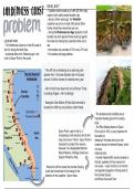
GEOLOGY
•* • • • E- B. ☒ a:$$ • • ☒±☒ñ - Coastline mainly made up of cliffs (20-30m high),
made of soft, easily eroded boulder clay.
- about a million years ago, the Yorkshire
⑧☒ ☒☒ Bath AMA coastline was a line of chalk cliffs almost 32km
.
further inland than where they are now
- during the Pleistocene Ice Age deposits of soft
boulder clay from glacial till were build up against
LOCATION the chalk and making the coastline further out to
- The Holderness Coast is on the NE coast of sea
the UK, facing the North Sea. - the boulder clay consists of 72% mud, 27% and
- It extends 60km from Flamborough in the 1% boulders and large pebbles
north to Spurn Point in the south.
- The cliff line is retreating at an alarming rate -
greater than 1.5m/year (fastest rate in Europe)
around 2 million tonnes of material every year
- 4km of land have been lost since Roman Times,
including villages + farm buildings
- Easington Gas Station (N Sea Gas terminal) is
located on cliffs top, its position under threat.
- The landward-side mudflats are an
Em important feeding ground for wading
birds
- The RNLI lifeboat station at Spurn
Spurn Point, a spit in the S, is Point, built in 1810, is very important for
increasingly at risk (erosion) and is 5km the safety of
long and covers 1.5km2 - Spurn Point is shipping in the area and is at a vital
important to protect from erosion, location along the Humber Estuary, which
because it is a designated National is a busy
Nature Reserve, Heritage Coast and shipping route.
Special Protection Area. - Humber Vessel traffic service located on
- Where the cliff line meets the Humber Estuary, •z the spit, operates 24-hour service for
river users. - major function is to monitor
and regulate navigation of those parts of
a spit has formed due to the change in the
direction of the coastline - Spurn Head. the Humber Estuary
and Rivers Ouse and Trent
MmmmmmmuwERB
, IE
g •É÷ *?•§ ÉE ¥ e-
EE
EF
is
¥ É¥=§¥ ⇐
☒
→
±
- The Holderness Coast is on the NE coast of the UK, facing the North Sea.
- It extends 60km from Flamborough in the north to Spurn Point in the south.
- one of the youngest natural coastlines of England
- Coastline mainly made up of cliffs (20-30m high), made of soft, easily eroded
- 61km long stretch of low glacial cliffs, 3m to 35m in height
boulder clay.
- stretches from FLAMBOROUGH HEAD in the north to SPURN HEAD in
- Where the cliff line meets the Humber Estuary, a spit has formed due to the
change in the direction of the coastline - Spurn Head. the south
- The cliff line is retreating at an alarming rate - greater than 1.5m/year (fastest - coast mainly exists of soft glacial drift cliffs, which have been cut back
rate in Europe) around 2 million tonnes of material every year 200m in the last century
- 4km of land have been lost since Roman Times, including villages + farm - on the softer sediment, the crumbling cliffs are fronted by beach-
buildings mantled abrasion ramps that decline gradually to a smoothed sea floor
- Easington Gas Station (N Sea Gas terminal) is located on cliffs top, its - a macrotidal coast
position under threat.
¥?É→
- about a million years ago the Yorkshire coastline was a line of white chalk cliffs almost 35km west of where it is now
- during the Pleistocene ice age (18,000 years ago) deposits of glacial till (soft boulder clay) were built up against these
cliffs to form a new coastline
- the boulder clay consists of about 72% mud, 27% sand and 1% boulders and large peddles
ÉoÉ É
- the coastline sweeps in a smooth ‘s shape’ from the south of BRIDLINGTON in the north to SPURN POINT in the
south at the mouth of the HUMBAR ESTUARY
- this smooth shale is only broken when sea defences have reduced erosion at the protected point and increased
southwards
- the seabed erodes by the action of waves, causing a deep infection of the area fronting the cliff
- the coast is subject to the full force of the waves from the NORTH SEA
- generally the natural beaches are almost always narrow and unable to stop wave action
- during the winter they are only a thin layer of sand covering the underlying clay, and in summer they’re built up
enough for recreational purposes
- there are dynamic sandbanks that are thought to move along the coast and make the most rapid areas od erosion at
the base of the cliff; this could be the main method of longshore drift on the Holderness