CORE PHYSICAL GEOGRAPHY
TOPIC 1: HYDROLOGY AND FLUVIAL GEOMORPHOLOGY
1.1 The drainage basin system
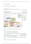
The global hydrological cycle refers to the movement of water between the atmosphere, lithosphere, and
biosphere.
Drainage basin density
THE LOCAL HYDROLOGICAL CYCLE
=total length of stream
The drainage basin is an open system as water is added as input and lost as output. ÷ area of drainage basin
KEY:
Input
Output
PRECIPITATION TRANSPIRATION Stores
Flows
INTERCEPTION
INFILTRATION
OVERLAND FLOW
EVAPORATION
THROUGHFLOW
PERCOLATION
GROUNWATER
FLOW
GROUNDWATER
BASEFLOW
Input
-Precipitation falls as rain, snow, hail at different time, intensity, and frequency.
Output
-Evaporation is the process of liquid→ gas by the addition of heat.
-Sublimation is the process of solid→ gas directly without liquid state.
-Transpiration is the process by which water vapour escapes from the plant Transpiration rate depends
from the stomata in the leaves. on the amount and type of
vegetation. Eg. tropical forest
-Evapotranspiration (EVT) is combined effect of evaporation from leaves ecosystem
and transpiration by the release of leaves from plant stomata.
-River discharge is the volume of water (in cumecs) being discharged in channels such as streams and rivers.
Stores
-Interception is the water caught and stored by vegetation.
, o Interception loss: water retained by the plant surface
o Throughfall: falls through gaps
o Stem flow: trickles along twigs and branches down main trunk
-Soil water is the subsurface water in gaps and pore spaces in soil and surface layers above the water table.
-Surface water is water that hasn’t infiltrated and stored on the surface of ground.
o Temporary sources: puddles, turloughs, seasonal lakes Occurs above impermeable
surfaces or ground where soil
o Permanent sources: lakes, wetlands, swamps, marshes, peat,
below is fully saturated→ pores
bogs
filled
-Groundwater is the water that has been percolated downwards and
stored in fault lines in aquifers below water table.
o The subsurface water that is stored under Water table is the upper zone of groundwater saturation and
the surface in rocks and accounts for 96.5% sediments (phreatic zone= the zone that is seasonally wetted and
of all fresh water on Earth. dried)
o May take 20000 years to be recycled Aquifers are rocks that contain significant quantities of water. Eg.
sandstone and limestone
Flows
-Overland flow (surface run off) occurs in two cases: -channel flow: small channels, rills,
less than 30cm deep, defined
o when precipitation exceeds the infiltration rate which may
be low due to tiny pore spaces. -sheet flow: rare, layer/sheet of water
on the ground
o when soil is saturated as pores are full
-Infiltration is the process by which water absorbs into small openings and pores in the ground (soil)
Infiltration capacity = the maximum rate at -Porosity is the capacity (size and no. of open pore spaces) of rock
which rain can enter the soil in a given to hold water
condition.
-Permeability is the ability to transmit water through a rock via
Eg. Sandstone: 5-15% porosity, 3-12mm/h joints + fissures→ size and no. of joints, fissures, fault lines and
infiltration capacity bedding planes
Clay: up to 50% porosity, 0-4mm/h infiltration
capacity (impermeable)
-Percolation is the process by which infiltrated water moves slowly downwards though the pores in soil into
the bedrock by gravity.
-Throughflow refers to the later downslope of movement within soil after it has been infiltrated, moving
towards the river channel through natural pipelines and percolines.
-Baseflow is water infiltrated and percolated into the bedrock of soil which moves laterally under gravity
downslope to feed springs and river channels. It is the rivers discharge from groundwater seeping into
waterbed.
Precipitation exceeds
-Groundwater recharge is when water is added to the water table due to the loss of
EVT+ water percolates
channel. down. Groundwater is
depleted and fills.
o It occurs due to infiltration, seepage, groundwater leakage/inflow, artificial
recharge.
o Losses of groundwater result from EVT, natural discharge, groundwater leakage, artificial abstraction.
,1.2 A Storm Hydrograph
Storm hydrographs are graphs that show how a drainage basin responds to a period of rainfall. They are useful
in planning for flood situations + times of drought as they show the discharge and base flow that originated as
precipitation.
River discharge(cumuecs)
Peak
rainfall
Peak
discharge
Lag time
Stormflow= water that
reaches the stream
Rainfall(mm)
Baseflow= normal
discharge
Time
Rainfall peak= the highest amount of rainfall that occurs during a rainfall event. -the lag time indicates how quickly
precipitation is reaching the river
Peak discharge= the time of the maximum amount of flow from the river. channel after rainfall.
Lag time= the time between peak rainfall and peak discharge. -the steepness of rising and falling limb
indicates how quickly the precipitation is
Rising limb= the period when discharge is rising from the start of the rainfall reaching the river channel and being
taken away by it.
event until it reaches peak discharge.
Falling limb= the period when discharge is falling.
**Approach segment is the time before water from rainfall gets to the channel.
Bank full discharge is the discharge of the river is at the top of the banks.
RIVER REGIMES
A river regime is the annual variation in the flow of a river. It is influenced by:
-climate
-amount+ nature of precipitation
-local rocks → porosity and permeability
-morphology of drainage basin
-amount + type of vegetation and soil cover
,FACTORS AFFECTING STORM HYDROGRAPHS
Climate Amount of rain ÷ time
-precipitation type and intensity: high intensity rainfall produces overland flow, steep rising limb and high peak
flow. Low intensity → infiltrate and percolate slowly, increasing time lag.
o Rain has a faster impact than snow.
o Rapid melting can cause flooding and high peak flows.
-temperature, evaporation, transpiration: temperature affects the evaporation rate → warm air can hold more
water so high peak flow is hot areas
-antecedent moisture: it is the amount of water or moisture retained in the soil before a rainfall event. If the
ground is saturated → overland flow, high peak flow and short time lag.
Equatorial climate is
**Soil type: sandy soil → high infiltration (large pore spaces) constant
Drainage basin characteristics
-drainage basin size: small responds quickly → short lag times
-drainage basin shape: circular basin causes lag time to be reduced and rising limb steep as speed of flow
increases. An elongated basin causes a flashy response but low peak discharge. Round basins create a longer
lag time but high peak discharge.
-drainage density: high density responds quickly since a shorter distance to flow → less water so shorter time
to reach channel
-porosity + impermeability: surfaces cause greater peak flows as water flows overland Permeable rock →
limestone + chalk
-rock type: impermeable rock causes greater peak flows (clay, igneous granite)
-slopes: steep slopes → overland flow, short lag time + high peak flows and flows quickly downhill with little
time to infiltrate. Human abstraction of
water leads to reduced
-vegetation type + density: interception of leaves flow
-land use: impermeable surfaces (concrete, roofs and roads) due to urbanisation → increased overland flow.
Pastoral farming → land is ploughed.
1.3 River channel processes and landforms
EROSION
Abrasion= coarse + angular rock dragged along beds and sides → potholes
Solution (corrosion)= acids in river water but contain certain minerals in solution. Affects calcareous rock
(limestone)
Hydraulic action= force of river penetrates joints in bed + sides → undercutting
Attrition (corrasion)= solid particles that form bedload collide with each other becoming smaller and rounder
, Factors affecting rates of erosion:
-load
-velocity + gradient
-geology
-pH
-human impact
TRANSPORTATION
Suspension= light material carried above riverbed by river flow (sand + silt)
The load of a river varies
Saltation= bedload bounce along riverbed, light enough to be entrained for a short distance with discharge + velocity
Traction= large rock and boulders roll along
Solution (corrosion)= transport of dissolved sediments that are products of solution weathering
DEPOSITION
A decline in the velocity of the river means there is less energy. This reduction of energy reduces the rivers
competence and therefore it is not able to carry its load. The river deposits its load, starting with the particles
of greatest size.
Factors that promote deposition:
-shallow gradient
-less water volume + increased load
-increased friction → reduced velocity
THE HJULSTROM CURVE
Capacity of a stream refers
to the largest amount of
debris that a stream can
carry.
Critical erosion velocity is
the lowest velocity at
which grains of a given size
can be moved.
The relationship between
these variables are shown
by the Hjulstrom curve.
**Larger particles → more
velocity to transport + deposit at higher velocities where small particles are still being transported.


