Arcgis pro - Samenvattingen en Aantekeningen
Op zoek naar een samenvatting over Arcgis pro? Op deze pagina vind je 20 samenvattingen over Arcgis pro.
Pagina 2 van de 20 resultaten
Sorteer op
-
Esri GIS Fundamentals Foundation Certification 2201 Questions and Answers 2024/2025
- Tentamen (uitwerkingen) • 20 pagina's • 2024
-
 TestTrackers
- €12,91
- + meer info
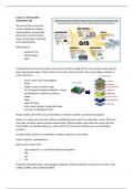
Datum - Provides a frame of reference for finding locations - Based on a spheroid Minor Axis - The shorter axis of the ellipse - North to South Shape of the Earth (Ellipsoid) Oblate Ellipsoid - because it rotates on the minor axis Prolate Ellipsoid If the Earth rotated about its major (longer; West/East) axis Ellipsoid a model of the rounded shape of earth (bulging at the equator) Measuring Ellipsoids Measured by semi-axes (half of an axis) - Semimajor and S...

-
ESRI Technical Certification exam 2024 with 100% correct answers
- Tentamen (uitwerkingen) • 5 pagina's • 2024
-
 YANCHY
- €17,24
- + meer info
An ArcGIS user chooses a mobile device to perform a field survey of road damage in an area. The user must obtain various types of information on the damage including surface type, damage, location, and an image of damage to the surface. Which ArcGIS platform application should be used for this task? - correct answer Collector for ArcGIS What is the default metadata style used by ArcGIS Pro? - correct answer Item Description An ArcGIS user is editing a parcel layer to reflect the additi...

-
Esri Technical Certification: Sample Questions for ArcGIS Desktop Entry
- Tentamen (uitwerkingen) • 10 pagina's • 2023
-
 Greaterheights
- €12,31
- + meer info
An ArcGIS user chooses a mobile device to perform a field survey of road damage in an area. The user must obtain various types of information on the damage including surface type, damage, location, and an image of damage to the surface. Which ArcGIS platform application should be used for this task? Drone2Map for ArcGIS Collector for ArcGIS Explorer for ArcGIS ArcGIS App - Answer- Collector for ArcGIS What is the default metadata style used by ArcGIS Pro? FGDC CSDGM metadata ...
-
Lecture notes of Advanced GIS for Geoscientists (GEO4-4433)
- College aantekeningen • 10 pagina's • 2024
-
 zitaswagten
- €6,49
- + meer info
These are the lecture notes of all the lectures in the course of Advanced GIS for Geoscientists. It gives you the basics of GIS.
-
Esri ArcGIS Desktop Associates Part 2 Questions and Answers 2024/2025
- Tentamen (uitwerkingen) • 3 pagina's • 2024
-
TestTrackers
- €10,34
- + meer info
Feature Class to Feature Class Converts a shapefile, coverage feature class, or geodatabase feature class to a shapefile or geodatabase feature class. Truncate Data This python tool can be used to replace field names or data with (_) or other corrections. Extremely helpful when importing tabular data. Swipe Function This tool can be used to compare layers such as yearly obesity from one year to the next using a swipe. Infographics Geoenrichment data available through...

Maak studiestress minder vervelend

-
esri exam questions with correct answers
- Tentamen (uitwerkingen) • 6 pagina's • 2023
-
cracker
- €14,29
- + meer info
What property of a shapefile should an analyst be aware of when creating statistics from numeric fields? Answer Shapefiles CANNOT store currency values. A GIS analyst is editing several feature classes associated with city utilities. The analyst selects a line feature class that represents the city's gas main, and opens Create Features. By default, which type of features are created? Answer Polylines An ArcMap user needs to inspect the geometry and attribute schema properties of a file g...
-
ESRI EXAM 1-30 QUESTIONS AN ANSWERS
- Tentamen (uitwerkingen) • 4 pagina's • 2023
-
Greaterheights
- €10,34
- + meer info
What property of a shapefile should an analyst be aware of when creating statistics from numeric fields? - Answer- Shapefiles CANNOT store currency values. A GIS analyst is editing several feature classes associated with city utilities. The analyst selects a line feature class that represents the city's gas main, and opens Create Features. By default, which type of features are created? - Answer- Polylines An ArcMap user needs to inspect the geometry and attribute schema properties of a ...
-
esri exam 1-30 questions and verified correct answers
- Tentamen (uitwerkingen) • 5 pagina's • 2023
-
 brittton
- €13,30
- + meer info
What property of a shapefile should an analyst be aware of when creating statistics from numeric fields? - correct answer Shapefiles CANNOT store currency values. A GIS analyst is editing several feature classes associated with city utilities. The analyst selects a line feature class that represents the city's gas main, and opens Create Features. By default, which type of features are created? - correct answer Polylines An ArcMap user needs to inspect the geometry and attribute schema pr...
-
Summary GRS-10306 Introduction Geo-Information Science
- Samenvatting • 11 pagina's • 2023
-
marclobregt
- €4,49
- + meer info
A summary of the course "GRS-10306 Introduction Geo-Information Science". The summary is based on the content threated during the lectures. Since all the content of the course is threated during the lectures, this summary is a great way to prepare for your exam! Een samenvatting van het vak "GRS-10306 Introduction Geo-Information Science". De samenvatting is gebaseerd op de inhoud van de colleges. Aangezien alle inhoud van het vak wordt behandeld tijdens de colleges, is deze samenvatting ...

-
Summary GRS10306 Introduction Geo-information science
- Samenvatting • 17 pagina's • 2021
-
jvanetten
- €3,49
- 2x verkocht
- + meer info
This is a summary based on the lectures that were given during the course Introduction Geo-Information science.
