Enquiry question 1 - why are coastal landscapes different and what processes cause these
differences?
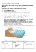
1.1 - the coast and wider littoral zone has distinctive features and landscapes
1.1.1 - the coast and wider littoral zone
coast - narrow strip of land where sea meets land
- divided into zones depending on what conditions are like on different sections of a coast
the littoral zone - wide coastal zone from highest sea level line linked with high tides to the shallow offshore
waters where the base of the wave first encounters friction with seabed
- a series of sub-zones to represent the features of the wider coastline from sea to land
- reaches dynamic equilibrium where there is a balance between inputs and outputs
- includes adjacent land areas and shallow parts of the sea just offshore
- offshore - the area of deeper water beyond the point at which waves begin to break, friction between
the waves and the sea bed may cause some distortion of the wave shape
- nearshore - the area of shallow water beyond the low tide mark, within which friction between the
seabed and waves distorts the wave sufficiently to cause it to break (breaker zone), there may be a
breakpoint bar between the offshore and nearshore zones
- foreshore - the area between the high tide and the low tide mark
- backshore - the area above the high tide mark, affected by wave action only during major storm events
- the littoral zone can include many types of habitats, the area can be thin or wide
inputs processes outputs
- solar energy - weathering - erosional landforms
- atmospheric - deposition - types of coasts
- human activity - mass movement - depositional landforms
- transport
- gravitational energy
- erosion
- geological
- marine
,the coast is a system - it has inputs, processes and outputs
when the inputs and outputs are balanced, they’re in dynamic equilibrium
1.1.2 High and low energy coasts
- energy is mostly provided by waves but also to some extent the weather, rivers and sea currents
type of wave (depends on):
- strength of the prevailing winds and
FETCH (distance of open water over
which wind blows)
high energy
- powerful waves
- rate of erosion > rate of deposition
low energy
- less powerful waves
- rate of deposition > rate of erosion
low energy high energy
wave characteristics - high wavelength - low wavelength
- low frequency - high frequency
- low amplitude - high amplitude
- short FETCH - long FETCH
- high swash - low swash
- low backwash - high backwash
- constructive - destructive
- calm - stormy
general location - sheltered from large waves - exposed to large waves
- low land coasts - highland and lowland coasts
- coastal plain landscapes - rocky landscapes
example locations - Mediterranean sea coasts - Atlantic coasts of Norway and
- East Anglian sea Scotland
- Pacific coasts of Alaska and
Canada
sediment is the key input and output of the system, and is determined by the action of waves, currents and
wind, with the output being the sediment washed out into the sea by deposition
1.2 - geological structure influences the development of coastal landscapes at a variety of scales
,1.2.1 - Concordant and discordant coastline
concordant - type of rock runs parallel to the coast discordant - type of rock runs perpendicular to the coast
example of a discordant coastline
- in Dorset, the coastland consists of Portland limestone and Greensands
- the Greensands is less resistant to erosional processes, and so retreats at a faster rate than the
Portland limestone
- this has resulted in the creation of a bay and headlands
coastal morphology - the shape of a coastline is continually changing because of the surrounding geology,
which contributes to its morphology
pacific coasts
- concordant coastlines, also referred to as Pacific coasts, lead to the formation of Dalmatian
coasts
- Dalmatian coasts are made up offshore islands and coastal inlets running parallel to the
coastline
- eg Lulworth Cove, located on the south-west Dorset coastline
- here, the more resistant rock acts as a barrier to protect the less resistant rock
atlantic coasts
- headlands and bays often form on discordant coastlines, also referred to as Atlantic coasts
- as the faster eroding, less resistant rock retreats (eg the clays at Swanage Bay), this leaves
behind the more resistant rock as headlands
- E.G South-West Ireland and on a smaller scale the
east-facing coast of Dorset
bays and headlands
- the retreating, less resistant rock and the exposed resistant rocks
cause a change in the shape of the coastline
- this leads to wave refraction
wave refraction
- because of bays, beaches and headlands, the depth of water around the coast varies and as a wave
approaches a coast its progress is modified due to friction from the seabed, halting the motion of waves
- as waves approach a coast they are refracted so that their energy is
concentrated around headlands but reduced around bays
- waves then tend to approach coastline parallel to it, and their
energy decreases as water depth decreases
- this change in the way in which waves approach the coastline can
cause an increase in the rate of erosion on the headlands
, - this leads to the formation of headland features like caves, arches, stacks and stumps
1.2.2 - Geological structure
coastal recession - coastal erosion
joints - fractures, caused either by contraction as sediments dry out or by earth movements during uplift
strata - layers of rock
dip - the angle at which rock strata lie (horizontally, vertically, dipping towards the sea or dipping inland
lithology - physical characteristics of particular rocks
coastal morphology - shape and form of coastal landscapes and their features
bedding planes - natural breaks in the strata, caused by gaps in time during periods of rock formation
folds - formed by pressure during periods of rock formation
faults - formed when the stress of pressure to which a rock is subjected, exceeds its internal strength causing it
to fracture, the faults then slip or move along fault planes
joints and faults
- the geological structure of rocks is caused by the deformation and stress placed on them from tectonic
processes
- rocks with the presence of more joints and faults, like sedimentary rocks, are more susceptible to the
processes of erosion and weathering
- this is because these processes exert forces on the weaknesses found in the layers of the rocks
dip
- the angle the rock layer forms with the horizontal bedding
plane
- rocks can dip either towards land or towards the sea
- bedding planes that dip towards the sea create a gentler
cliff profile, but these cliffs are vulnerable to mass
movement processes like rockfalls
- bedding planes that dip towards land to create a steeper
cliff profile, but these cliffs are more vulnerable to erosion
processes, like hydraulic action and abrasion
landward dip
- cliff profile is steep at around 70-80 degrees
- very stable
- rockfall is reduced
horizontal dip
- vertical or near vertical profile
- notches reflect strata that are more easily eroded
- rockfall is common
steeply dipping seaward
- unstable
- rockfall is increased
- sloping, low angle profile with one rock layer facing the sea
- vulnerable to rock slides down the dip slope
gently dipping seaward
- profile may exceed 90 degrees producing areas of overhanging rock
The benefits of buying summaries with Stuvia:
Guaranteed quality through customer reviews
Stuvia customers have reviewed more than 700,000 summaries. This how you know that you are buying the best documents.
Quick and easy check-out
You can quickly pay through EFT, credit card or Stuvia-credit for the summaries. There is no membership needed.
Focus on what matters
Your fellow students write the study notes themselves, which is why the documents are always reliable and up-to-date. This ensures you quickly get to the core!
Frequently asked questions
What do I get when I buy this document?
You get a PDF, available immediately after your purchase. The purchased document is accessible anytime, anywhere and indefinitely through your profile.
Satisfaction guarantee: how does it work?
Our satisfaction guarantee ensures that you always find a study document that suits you well. You fill out a form, and our customer service team takes care of the rest.
Who am I buying this summary from?
Stuvia is a marketplace, so you are not buying this document from us, but from seller amelie3. Stuvia facilitates payment to the seller.
Will I be stuck with a subscription?
No, you only buy this summary for R70,48. You're not tied to anything after your purchase.