A summary of grade 11 geomorphology taken from the Platinum textbook. Covers topography associated with horizontally layered rocks, topography associated with inclined rock strata, topography associated with massive igneous rocks, slopes and, mass movements and human responses.
Chapter 1: topography associated with horizontally layered rocks
• Weathering: the breakdown of rocks into smaller pieces.
o Mechanical weathering due to temperature differences.
o Chemical weathering due to chemical reaction with minerals in rock and water.
o Biological weathering due to where plants or animals break the rocks down.
• Erosion: the removal of broken rock material by an agent such as wind, water or ice.
• Horizontally: parallel to the horizon.
Characteristics and processes associated with the development of hilly landscapes
• Flat-topped hills are formed in three ways:
o Horizontally laid sedimentary rock:
§ Sedimentary rocks are made up of layers which may weather and erode at
different rates (E.g., Shale erodes faster than sandstone).
o Igneous intrusions – sills:
§ Igneous intrusions form when hot magma is squeezed between two layers of
sedimentary rock, cools and solidifies.
§ In South Africa, most igneous sills are dolerite (E.g.,
Platberg in Harrismith)
§ Igneous rock does not erode as quickly as sedimentary
rock and forms a flat-topped hill when exposed on Earth’s
surface.
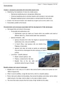
Basalt cliff
o Lava flows – basaltic plateaus:
§ Basalt: volcanic igneous rock.
§ Plateau: a raised level or flat area.
Sandstone
§ Basaltic flow at the top (old) and
sandstone below the layer of basalt.
Basaltic plateau and canyon landscapes
• Basaltic lava is very runny so it is able to flow across Earth’s surface and spread out over
1000s of square kms.
• When it cools & solidifies, a large flat area forms, which is a basaltic plateau.
• Rivers, that carve valleys into this plateau, flow across the plateau carve deep, narrow valleys
called canyons. Any deep, narrow valley in a dry area is called a canyon.
• The rivers that erode canyons flow from areas of high rainfall into the valley.
1
, Grade 11 – Platinum Geography (139-184)
• E.g., The Grand Canyon, which was eroded by the Colorado
River, is composed of many layers of sedimentary rocks, each
with different resistance to weathering and erosion.
• The more resistant layers of rock wear back slowly, creating
steep slopes, while the softer rock wears back faster, creating
more gentle slopes.
Karoo landscapes (mesa, butte and conical hill)
• Back wasting/scarp retreat: slopes eroding back
parallel to their original position, common in dry
climates where there is very little surface water runoff.
• Mesa: flat-topped hill with the distance across its top
being greater than its height.
• Butte: smaller than a mesa; a flat-topped hill with a
distance across its top being less than its height.
• Conical hill: a rounded hill that forms after the resistant cap rock of a mesa or butte has been
removed by weathering and erosion.
• In arid and semi-arid area, there is little rainfall, so there is little surface runoff of water to
move eroded material down slopes. Erosion in these areas occurs at very slow rates.
• Over long periods of time, the canyons that are carved into plateau by back wasting.
• Mesa becomes a butte becomes a conical hill over time.
Scarp retreat (back wasting)
• Slopes eroding back parallel to their original position; common in dry climates where there is
very little surface run off.
• Karroo landscapes generally have concave slopes.
• Stage one:
o As pieces of rock for from the cliff face the cliff
wears back parallel to the original position. The broken pieces of rock collect on the
talus slope below. The small broken pieces of rock break down fairly quickly because
they already fragmented. As a result, the angle of the talus like remains parallel to
original position.
• Stage two:
o Where scarp retreat and parallel back wasting take place the plateau area decreases
but the cliff and the talus keep the same angle.
2
The benefits of buying summaries with Stuvia:
Guaranteed quality through customer reviews
Stuvia customers have reviewed more than 700,000 summaries. This how you know that you are buying the best documents.
Quick and easy check-out
You can quickly pay through EFT, credit card or Stuvia-credit for the summaries. There is no membership needed.
Focus on what matters
Your fellow students write the study notes themselves, which is why the documents are always reliable and up-to-date. This ensures you quickly get to the core!
Frequently asked questions
What do I get when I buy this document?
You get a PDF, available immediately after your purchase. The purchased document is accessible anytime, anywhere and indefinitely through your profile.
Satisfaction guarantee: how does it work?
Our satisfaction guarantee ensures that you always find a study document that suits you well. You fill out a form, and our customer service team takes care of the rest.
Who am I buying this summary from?
Stuvia is a marketplace, so you are not buying this document from us, but from seller kaityjericevich. Stuvia facilitates payment to the seller.
Will I be stuck with a subscription?
No, you only buy this summary for R80,00. You're not tied to anything after your purchase.